Big Bend National Park Map
15 trails mapped — click a pin to learn more
Big Bend National Park at a Glance
4 alertsBig Bend National Park covers 801,163 acres of Chihuahuan Desert along the Rio Grande in far west Texas. Getting here is a commitment. The nearest town with a grocery store is about 100 miles away. The nearest major airport is roughly 330 miles. The summer heat regularly exceeds 110 degrees F in the lowlands. None of this is a complaint. It is a filter, and it works. Big Bend is one of the least visited national parks in the lower 48, which means the trails are empty, the skies are dark, and the landscape feels like it belongs to you.
The hiking here ranges from flat desert walks along the Rio Grande to strenuous mountain climbs in the Chisos Basin. You can do a 1-mile walk to hot springs on the river or a 30-mile backpacking loop through the Chisos Mountains. The variety is surprising for a park that most folks write off as “just desert.”
Here are the 15 best hikes in Big Bend National Park, from my own trips through this place.
A Serious Note About Heat
I need to say this up front. Big Bend heat kills people. Between May and September, daytime temperatures in the desert lowlands (the Rio Grande Village area, Santa Elena Canyon, Boquillas Canyon) routinely hit 105 to 115 degrees F. The Chisos Basin sits at around 5,400 feet and stays 10 to 15 degrees cooler, but even there, summer hiking is no joke.
If you visit in summer, restrict lowland hikes to before 10am or after 5pm. Carry at least 1 gallon of water per person for any hike over 3 miles. The park service is not exaggerating when they say it. I have personally gone through 4 liters on the Emory Peak trail in October, and October is supposed to be the “cool” season.
Late October through March is the ideal window. The desert temperatures are manageable, the Chisos are cool and pleasant, and the light is spectacular.
1. Lost Mine Trail
Distance: 4.8 miles round trip | Elevation Gain: 1,100 feet | Difficulty: Moderate | Time: 2.5 to 4 hours
Lost Mine Trail is the single best hike in Big Bend National Park. I would put it in the top 20 day hikes in the entire national park system. The trail climbs steadily from the Chisos Basin through pinyon-juniper-oak woodland, with views that keep expanding the higher you go. By the time you reach the summit ridge, you can see into Mexico, across the Chisos Mountains, and down into the vast desert floor below.
The trailhead is at Panther Pass, the highest point on the road through the Chisos Basin. Start early. This trail gets direct sun on the switchbacks, and the parking area fills by 9am in peak season. The upper section follows a narrow ridge with drop-offs on both sides that will wake you up if you are still half-asleep from the drive.
For photographers, morning light is better here. The east-facing views catch the sunrise beautifully, and the haze is thinner before midday.
2. Emory Peak Trail
Distance: 10.5 miles round trip | Elevation Gain: 2,500 feet | Difficulty: Strenuous | Time: 5 to 8 hours
At 7,832 feet, Emory Peak is the highest point in Big Bend National Park. The hike starts at the Chisos Basin trailhead, climbs through the Pinnacles Trail, and ends with a Class 2 rock scramble up the final 50 feet to the summit. That last section involves pulling yourself up exposed rock with hand and foot holds. It is not technical climbing, but it is not a walk either. Folks with a fear of heights should know what they are signing up for.
The summit views are a 360-degree panorama that, on a clear day, extends over 100 miles into Mexico. I sat up there for 45 minutes on my last trip just watching the shadow of the mountain creep across the desert floor as the sun moved.
Bring way more water than you think you need. There is no water on this trail. I carried 4 liters and wished I had brought a fifth.
3. Santa Elena Canyon Trail
Distance: 1.4 miles round trip | Elevation Gain: 80 feet | Difficulty: Easy to Moderate | Time: 45 minutes to 1 hour
Santa Elena Canyon is the most photographed spot in Big Bend, and it earns every frame. The canyon walls rise 1,500 feet straight up from the Rio Grande, and the trail takes you right into the mouth of it. Mexico is on your left, Texas on your right, and the river flows between 1,500-foot limestone walls that block out most of the sky.
The trail starts with a concrete walkway, then crosses Terlingua Creek (which may require wading in spring or after heavy rain), climbs a set of switchbacks, and descends to the river’s edge inside the canyon. The acoustics in there are something else. Your footsteps echo off the walls. The river sounds amplified. It is a genuinely powerful place.
Late afternoon light is the time to be here. The sun hits the east wall and turns the limestone bright orange while the west wall stays in deep shadow. The contrast is extraordinary.
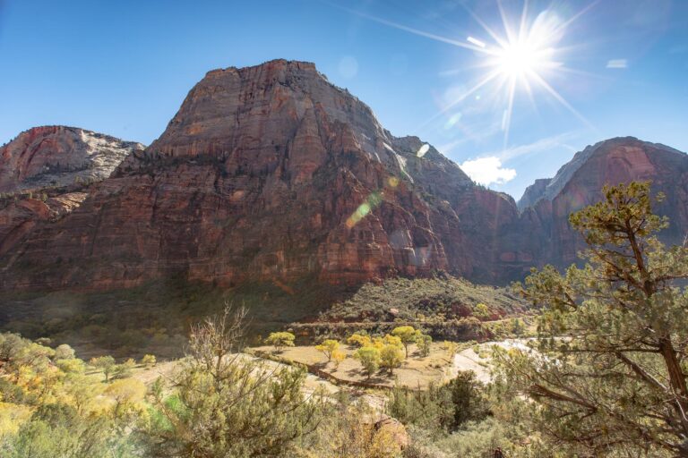
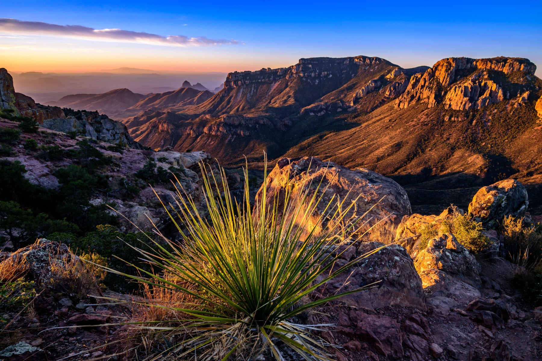
4. South Rim Trail
Distance: 12 to 14.5 miles round trip (depending on route) | Elevation Gain: 2,500 feet | Difficulty: Strenuous | Time: 7 to 10 hours (or overnight)
The South Rim loop is the most rewarding hike in the park if you have the fitness and the time. The trail climbs from the Chisos Basin through Boot Canyon (named for the boot-shaped rock formation you will pass), winds through high-elevation forest with Arizona cypress and ponderosa pine, and emerges at the South Rim with views that drop 2,000 feet straight down to the desert floor.
Most folks do this as a long day hike, taking the Laguna Meadow Trail up and the Pinnacles Trail down (or vice versa) to make a loop. You can also backpack it with a permit and camp at one of the designated backcountry sites near the rim. The sunset from the South Rim backcountry campsite is one of the best things I have ever seen in a national park. Mexico stretches out endlessly below you, painted in reds and purples as the sun drops.
Do not underestimate this one. The mileage is real, the elevation gain is real, and the Chisos Basin trailhead sits at 5,400 feet, so you are working harder than the numbers suggest.
5. The Window Trail
Distance: 5.6 miles round trip | Elevation Gain: 950 feet | Difficulty: Moderate | Time: 2.5 to 4 hours
The Window is a V-shaped notch in the Chisos Mountains where Oak Creek pours through a narrow gap in the rock and drops into the desert below. The trail descends from the Chisos Basin Lodge through a desert wash, following the creek bed down to the pouroff point. Standing at The Window, you look out through the gap at the desert floor hundreds of feet below, perfectly framed by the rock walls on either side.
Here is the catch. This trail goes downhill on the way out and uphill on the way back. Most folks forget this until they are halfway to the car, 950 feet of elevation gain ahead of them, wondering why their legs are complaining. Start this hike with enough water and energy for the return trip.
Sunset at The Window is the classic Big Bend experience. The sun drops directly into the notch, silhouetting the rock walls. Time it right and you will understand why so many photographs of this park feature this exact spot.
6. Hot Springs Trail
Distance: 1 mile round trip | Elevation Gain: Minimal | Difficulty: Easy | Time: 30 minutes to 2 hours (depending on soaking time)
A short walk to a natural hot spring on the banks of the Rio Grande. The spring maintains a temperature of about 105 degrees F year-round, and the NPS has built a stone-lined pool where you can sit and soak with Mexico about 30 feet away across the river. The trail also passes the ruins of a 1909 trading post and bathhouse, with interpretive panels explaining the area’s history.
There are pictographs on the canyon walls near the hot spring, some dating back over 1,000 years. Most folks miss them because they are focused on the water. Look up.
This is best in winter. Soaking in 105-degree water when the air is 40 degrees is perfect. Doing it when the air is 105 degrees is a different kind of experience entirely.
7. Boquillas Canyon Trail
Distance: 1.4 miles round trip | Elevation Gain: 150 feet | Difficulty: Easy to Moderate | Time: 45 minutes to 1 hour
Boquillas Canyon is the longest canyon on the Rio Grande in Big Bend, stretching 33 miles through limestone walls. The trail gives you a taste of it. You climb a short sandy hill, drop down to the river, and walk along the bank into the mouth of the canyon. The walls rise several hundred feet on both sides, and the river bends out of sight ahead of you.
The trail is sandy and can be slow-going in spots. The sand slides under your feet like walking on a beach. But the canyon itself is quieter and less visited than Santa Elena, and I find the atmosphere more contemplative. You can sometimes hear singing from the Mexican village of Boquillas del Carmen across the river. Folks from the village occasionally leave handmade crafts at the trailhead with a box for voluntary payment.
8. Grapevine Hills Trail
Distance: 2.2 miles round trip | Elevation Gain: 240 feet | Difficulty: Easy to Moderate | Time: 1 to 1.5 hours
Grapevine Hills is a short hike through a boulder field to one of the most Instagram-famous spots in Big Bend. The “balanced rock” at the end of the trail is a massive boulder perched on two others, creating a natural window that frames the desert and the Chisos Mountains in the distance. Every photographer who has ever been to Big Bend has this shot.
The trail follows a sandy wash for the first mile, then scrambles up through house-sized boulders for the final approach. The rock scrambling is not difficult, but younger kids might need a hand. The trailhead is at the end of a 6.4-mile gravel road that is rough but passable for most vehicles.
I like this trail in the late afternoon when the boulders cast long shadows and the balanced rock is backlit. Morning works too, but the lighting on the Chisos in the background is better in the last hour before sunset.
9. Chisos Basin Loop Trail
Distance: 1.8 miles round trip | Elevation Gain: 350 feet | Difficulty: Easy to Moderate | Time: 45 minutes to 1 hour
This loop trail circles the floor of the Chisos Basin and is the best introductory hike in the park. It starts near the lodge and winds through grasslands and oak-juniper woodland with views up at the surrounding peaks. The Window is visible from several points on the trail, framed between the basin walls.
I always recommend this trail for your first morning in the park. It gets your legs moving, gives you a sense of the Chisos Basin layout, and helps you figure out which bigger trails you want to tackle. It is also one of the best trails in the park for bird watching. The Chisos are home to the Colima warbler, which breeds nowhere else in the United States.
10. Mule Ears Spring Trail
Distance: 3.8 miles round trip | Elevation Gain: 200 feet | Difficulty: Moderate | Time: 1.5 to 2.5 hours
The Mule Ears are twin rock spires that rise from the desert floor like pointed ears, visible from the Ross Maxwell Scenic Drive. The trail to the spring at their base crosses open desert with virtually no shade, passing through creosote bush and lechuguilla before arriving at a small oasis where water seeps from the rock. In a park this dry, any water source feels like finding treasure.
This is a lowland trail, which means it is absolutely brutal in summer. I would not hike it between May and September unless you start at dawn. In the cooler months, it is a pleasant walk through classic Chihuahuan Desert landscape with the Mule Ears growing larger and more imposing with every step.
11. Pine Canyon Trail
Distance: 4 miles round trip | Elevation Gain: 1,000 feet | Difficulty: Moderate | Time: 2 to 3 hours
Pine Canyon is one of the least-hiked trails in Big Bend, partly because the trailhead requires a 4-mile drive on a rough dirt road that some vehicles will not enjoy. The trail follows a dry wash into a narrowing canyon, climbing gradually through desert scrub into an unexpected forest of ponderosa pine, Douglas fir, and Arizona cypress. At the end, a 200-foot pouroff creates a seasonal waterfall after heavy rains.
Even when the pouroff is dry (which is most of the time), the canyon is worth the trip. The transition from open desert to dense forest happens quickly and the temperature drops noticeably as you enter the shade. I had this entire trail to myself on a November afternoon, which felt like a luxury in a national park.
12. Marufo Vega Trail
Distance: 14 miles round trip | Elevation Gain: 1,600 feet | Difficulty: Strenuous | Time: 7 to 10 hours
Marufo Vega is the most challenging maintained trail in the lowlands, and it is one that most guidebooks barely mention. The loop descends from the Rio Grande Village area through limestone canyons, drops to the river, follows the bank for several miles, and then climbs back up through rugged terrain to the trailhead.
This is a trail for experienced desert hikers only. There is no shade, no water, and limited trail markings in some sections. Navigation skills are essential. The NPS recommends carrying a minimum of 1 gallon of water per person and not attempting this trail from April through October.
What you get in return is total solitude and some of the most dramatic Rio Grande scenery in the park. The canyon sections feel ancient and undiscovered. If you have the experience and the fitness, this is Big Bend at its rawest.
13. Chimneys Trail
Distance: 4.8 miles round trip | Elevation Gain: 350 feet | Difficulty: Moderate | Time: 2 to 3 hours
The Chimneys are a cluster of rock formations in the western desert that contain some of the best-preserved pictographs in Big Bend. The trail crosses open desert, so bring sun protection, but the destination is worth the exposure. The rock art includes images attributed to multiple cultures spanning thousands of years, layered on top of each other on the same rock faces.
Beyond the pictographs, the formations themselves are interesting. They are volcanic remnants that have weathered into chimney-shaped columns. The isolation out here is real. You are miles from the nearest road with nothing but open desert in every direction. For more on the park’s geological and cultural history, check out our Big Bend facts page.
14. Rio Grande Village Nature Trail
Distance: 0.75 miles round trip | Elevation Gain: 50 feet | Difficulty: Easy | Time: 20 to 30 minutes
This short loop trail is in the Rio Grande Village area, the lowest and hottest part of the park. The trail passes through a dense thicket of reeds and cottonwoods along the river, then climbs a small hill for a panoramic view of the desert, the river, and the mountains of Mexico.
The birding here is the best in the park. Rio Grande Village sits on a major flyway, and the combination of river, desert, and vegetation creates habitat that draws species from both sides of the border. I have seen vermilion flycatchers, painted buntings, and several species of hummingbirds on this one short trail. If you are a birder, bring your binoculars and plan to spend more time here than the trail length suggests.
15. Outer Mountain Loop
Distance: 30 miles | Elevation Gain: 5,000+ feet | Difficulty: Very Strenuous | Time: 2 to 4 days
This is the big one. The Outer Mountain Loop is a multi-day backpacking trip that circumnavigates the Chisos Mountains, dropping from the basin into the desert lowlands, traversing the western slopes, and climbing back up through the Pinnacles. It is the most demanding trail in the park, and it requires a backcountry permit, careful water planning, and genuine desert hiking experience.
Water availability is the critical factor. There are no reliable water sources on large sections of the loop, and you may need to cache water at road crossings before starting. The NPS strongly recommends against attempting this trail from April through October due to extreme heat in the lowland sections.
For experienced backpackers, this loop is one of the great trails in the Southwest. The variety of ecosystems you pass through, from montane forest to open desert to riparian corridor, is remarkable for a single trail. You finish the loop with a deeper understanding of how this park fits together than any day hike can provide.
Tips for Hiking in Big Bend
Water, water, water. I cannot say this enough. The NPS recommends 1 gallon per person per day for desert hiking. That sounds like a lot until you are 3 miles into a shadeless trail and your first liter is already gone. Carry more than you think you need. There is no potable water on any trail in the park.
Gas up before you arrive. The nearest gas stations are in Study Butte/Terlingua, about 25 miles from the Chisos Basin. There is no gas inside the park. Running out of gas in Big Bend is a genuine emergency because cell service is essentially nonexistent.
Watch for mountain lions. Big Bend has one of the densest mountain lion populations of any national park. Sightings are uncommon but they happen. Make noise on the trail, hike in groups when possible, and never approach a mountain lion if you see one.
Cell service. There is none. Not in the Chisos Basin, not at Rio Grande Village, not at Castolon. A few spots near the border might pick up a Mexican cell signal, but do not count on it. Bring paper maps and tell someone your itinerary before you go.
Stargazing. Big Bend has some of the darkest skies in North America. On a clear night, you can see the Milky Way with the naked eye so clearly it looks like a photograph. Stay up late at least one night. You will not regret it.
When to Visit Big Bend
Late October through March is the prime window. November and February are my personal favorites. The desert temperatures are comfortable in the 60s and 70s, the Chisos are cool but not cold, and the crowds (already thin by national park standards) drop to almost nothing on weekdays.
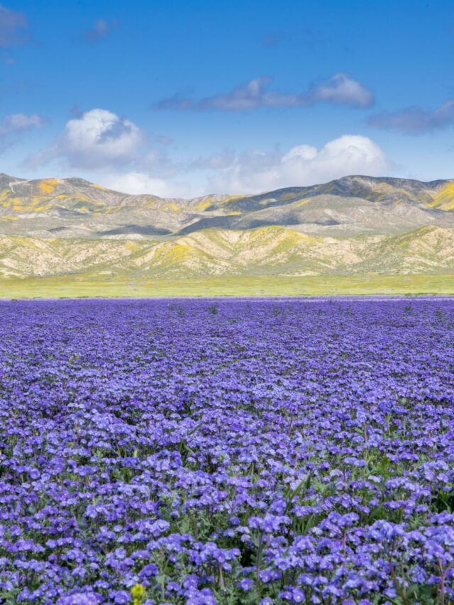
Spring (March and April) brings wildflower blooms in good rainfall years, but temperatures start climbing rapidly by late March. Summer is only for the Chisos Basin trails, and even those require early starts. For a full look at what else the park offers beyond hiking, check out our guide to 20 things to do in Big Bend National Park. If you are planning a broader Texas national parks trip, Big Bend pairs well with Guadalupe Mountains, about 4 hours northwest.
Frequently Asked Questions
Lost Mine Trail. It is 4.8 miles round trip with 1,100 feet of elevation gain, and the summit views are the best you will find on any day hike in the park. If you can only do one trail, make it this one.
Yes. Incidents between park visitors and border-related activity are extremely rare. The park has been visited safely by millions of people. The Boquillas border crossing is in the state of Coahuila, which carries an ‘Exercise Increased Caution’ advisory, the same level as many popular tourist destinations. Use common sense, check the latest State Department guidance, and enjoy the park.
3 days minimum. Day 1 for the Chisos Basin trails (Lost Mine, Window), Day 2 for Santa Elena Canyon and the Ross Maxwell Scenic Drive, and Day 3 for the Rio Grande Village area (Hot Springs, Boquillas Canyon, nature trail). 4 to 5 days lets you add Emory Peak or the South Rim.
Technically yes, but the NPS does not recommend it. The river can have strong undercurrents, and water quality is not monitored. If you do wade in (which many folks do at Santa Elena or Hot Springs), stay in shallow areas and do not drink the water.
What to Bring to Big Bend
Gear we recommend for Big Bend. Affiliate links support our work at no cost to you.
Affiliate disclosure: Some links on this page earn us a small commission at no extra cost to you. We only recommend gear we actually use.