Some of the best weeks of my life have been spent driving between national parks with my brother Will, a trunk full of camera gear, and a vague plan. There is no better way to understand this country than to string its parks together on a road trip and watch the landscape transform mile by mile. The deserts give way to mountains, the mountains to coast, and you start to feel just how big and varied America really is.
Below are ten of my favorite national park road trips across the country, grouped by region. Each one connects parks that genuinely belong together, with rough distances, how long to give it, and the best season to go. Pick the one that fits your time and start planning.
National Park Road Trips at a Glance
| Route | Region | Days | Best Season |
|---|---|---|---|
| The Mighty 5 | Utah | 7 to 10 | Spring, fall |
| Grand Circle | Southwest | 10 to 14 | Spring, fall |
| California Parks | California | 7 to 12 | Spring, fall |
| Pacific Northwest | Washington | 7 to 10 | Summer |
| Greater Yellowstone | Northern Rockies | 7 to 10 | Summer, early fall |
| Glacier and the Rockies | Montana, Colorado | 10 to 14 | Summer |
| Great Plains | Dakotas | 5 to 7 | Late spring, fall |
| Appalachian East | East Coast | 5 to 8 | Fall |
| Desert Southwest | CA, NV, AZ | 7 to 10 | Late fall to spring |
| Colorado and Mesa Verde | Colorado | 5 to 8 | Summer, early fall |
1. Utah’s Mighty 5

This is the classic American road trip and the one I recommend first. You connect all five of Utah’s national parks, each one a completely different take on red rock: Zion, Bryce Canyon, Capitol Reef, Arches, and Canyonlands. The drive between them along Scenic Byway 12 is one of the best stretches of road in the country.
Parks Featured in This Guide
3 parks mapped — click a pin for details
109 public lands destinations are under threat. Get the free weekly briefing that 25,000+ people use to stay informed and take action.
- Distance and time: Roughly 800 to 900 miles depending on your loop. Give it 7 to 10 days to do it justice.
- Best season: Spring and fall for mild temperatures. Summer is hot at the lower parks like Zion and Arches, and Bryce stays cooler at elevation.
- Plan for: Zion’s shuttle in the busy season and Arches timed-entry reservations if they are in effect during your visit.
2. The Grand Circle

The Grand Circle widens the Mighty 5 into a loop through the broader Colorado Plateau, adding the Grand Canyon and Mesa Verde, along with iconic spots like Monument Valley, Antelope Canyon, and Horseshoe Bend in between. It is the definitive Southwest sampler and packs in more memorable scenery per mile than almost anywhere.
- Distance and time: Around 1,400 miles for the full loop. Plan 10 to 14 days, more if you slow down.
- Best season: Spring and fall. The desert parks are punishing in midsummer and the Grand Canyon’s North Rim closes in winter.
- Base towns: Page, Moab, and Springdale make good hubs along the way.
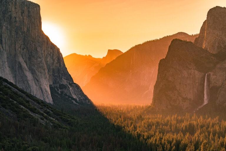
3. California National Parks

California has more national parks than any other state, and you can chain several into one trip: Yosemite, Sequoia, and Kings Canyon form a natural core in the Sierra Nevada, and ambitious travelers can add Death Valley and Joshua Tree to the south.
- Distance and time: The Sierra core is a tidy week. Adding the desert parks stretches it to 700 to 900 miles and 10 to 12 days.
- Best season: Late spring and fall balance the high Sierra and the low deserts. Yosemite’s Tioga Road and high country are snowbound much of the year.
- Plan for: Yosemite reservations during peak periods, and never the desert parks in summer heat.
4. Pacific Northwest Parks

Washington’s three national parks make a tight, scenic loop: Mount Rainier, Olympic, and North Cascades. In a single trip you go from a glaciated volcano to a temperate rainforest and wild coast to a wall of jagged alpine peaks, all within a few hours of Seattle.
- Distance and time: Roughly 600 miles for the loop. Plan 7 to 10 days.
- Best season: Summer, particularly July through September, when the high roads and trails are open and the wildflowers peak at Rainier.
- Plan for: Timed-entry or reservation systems that have applied to popular areas like Rainier’s Paradise in recent seasons.
5. Greater Yellowstone

Pairing Yellowstone and Grand Teton is one of the great wildlife road trips in the country. The two parks share a boundary, so you can move easily from Yellowstone’s geysers and bison herds to the Tetons’ soaring granite peaks and glacial lakes in a single drive.
- Distance and time: The two parks alone reward a full week. With travel to and from, plan 7 to 10 days.
- Best season: Summer for full road access and wildlife, with early fall offering the elk rut and fewer people.
- Base towns: Jackson, Wyoming anchors the south, and West Yellowstone the west.
6. Glacier and the Rockies

For high alpine scenery, link Glacier in northern Montana with Rocky Mountain in Colorado, two parks built around the Continental Divide. Both feature legendary high roads, Glacier’s Going-to-the-Sun Road and Rocky Mountain’s Trail Ridge Road, that climb above treeline into a world of glaciers, wildflowers, and big wildlife.
- Distance and time: These parks are far apart, so this is a longer haul of 10 to 14 days across roughly 1,200 miles.
- Best season: Summer. Both high roads are only fully open for a short window, often roughly July into September.
- Plan for: Vehicle reservation systems that have applied to both Glacier and Rocky Mountain in recent summers.
7. Great Plains and the Dakotas

This underrated route through the Dakotas connects Badlands, Wind Cave, and Theodore Roosevelt, with the Black Hills, Mount Rushmore, and Custer State Park in between. You get eroded badlands, one of the longest cave systems on Earth, free-roaming bison, and the quiet, big-sky country that shaped a president.
- Distance and time: Around 600 to 700 miles. Plan 5 to 7 days.
- Best season: Late spring and early fall for mild weather and active wildlife. Summer afternoons bring heat and thunderstorms.
8. The Appalachian East Coast

The East Coast has its own great park drive, linking Great Smoky Mountains, Shenandoah, and, for the ambitious, Acadia in Maine. The Blue Ridge Parkway and Skyline Drive connect the two southern parks in a ribbon of ridgeline overlooks, and Acadia adds a rugged coast far to the north.
- Distance and time: The Smokies and Shenandoah pair into a tidy 5 days. Adding Acadia makes it a long, rewarding 8-day haul up the coast.
- Best season: Fall, hands down, for some of the best foliage in the country. Acadia and Shenandoah peak in October.
- Plan for: Cadillac Mountain sunrise vehicle reservations at Acadia in season.
9. The Desert Southwest

This route strings together the great desert parks of California, Nevada, and Arizona: Joshua Tree, Death Valley, and the Grand Canyon, with Las Vegas as a convenient hub. It is a study in extremes, from the lowest point in North America to the rim of the most famous canyon on the planet.
- Distance and time: Roughly 800 miles. Plan 7 to 10 days.
- Best season: Late fall through spring. These parks, especially Death Valley, are genuinely dangerous in summer heat.
10. Colorado and Mesa Verde
Colorado offers a varied loop anchored by Rocky Mountain in the north and Mesa Verde in the southwest, with the option to add Great Sand Dunes and Black Canyon of the Gunnison along the way. You go from high alpine tundra to ancient cliff dwellings to towering sand dunes, a remarkable range for one state.
- Distance and time: Around 600 to 800 miles depending on which parks you add. Plan 5 to 8 days.
- Best season: Summer and early fall, when Rocky Mountain’s Trail Ridge Road is open and the high country is accessible.
Planning a National Park Road Trip
Reservations and Passes
If you are hitting three or more parks, the America the Beautiful annual pass pays for itself quickly and covers entry at every national park. Many popular parks now use timed-entry or vehicle reservation systems in peak season, including Arches, Yosemite, Glacier, Rocky Mountain, and Mount Rainier in recent years, so check each park’s current rules before you go.
When to Go
Match your route to the season. Desert parks shine from late fall through spring and are dangerous in summer. High-country parks like Glacier, Rocky Mountain, and the Pacific Northwest are best in mid to late summer when the alpine roads open. The East Coast peaks in fall foliage. Plan around the calendar and the parks reward you.
How to Pace It
The most common mistake is trying to do too much. Build in at least a full day at each major park, account for the long drives between them, and leave room for the unplanned stops that often become the best memories. A slower trip through fewer parks beats a frantic checklist every time.
What to Pack
Carry more water than you think you need, especially in the desert, along with layers for big temperature swings between day and night and between low desert and high mountains. Download offline maps, since cell service drops out in most parks, and keep your fuel tank topped off, because gas stations can be far apart out west.
Ready to plan? Dig into the individual park guides linked above for trails, lodging, and the latest on fees and reservations, and build the route that fits your time and your sense of adventure.