The Zion-Mt. Carmel Highway is 11 miles of the most dramatic road engineering you’ll ever see in a national park. It connects Canyon Junction to Zion’s east entrance, cutting through 1.1 miles of solid sandstone tunnel and climbing a series of switchbacks that put you eye-level with formations most people only see from the valley floor.
I’ve driven this road probably 40 or 50 times at this point, in every season, in every kind of light. And I still pull over constantly. That’s not something I can say about most scenic drives in the national park system.
If you’re planning a trip to Zion National Park, the Mt. Carmel Highway deserves more than just a pass-through on your way to or from Bryce Canyon. Here’s everything you need to know to do it right.
What Is the Zion-Mt. Carmel Highway?
The highway runs along State Route 9 from Canyon Junction (where the Zion Canyon Scenic Drive meets the main road) east to the park boundary near Mt. Carmel Junction. It was built between 1927 and 1930, and the construction was genuinely remarkable for its era. Workers blasted a 1.1-mile tunnel through the Navajo Sandstone, making it one of the longest tunnels in the United States when it opened.
The road gains about 850 feet of elevation from the canyon floor to the high plateau on the east side. That climb happens fast, through a series of tight switchbacks carved into the cliff face with gallery windows cut into the tunnel walls to let in light and air. Those windows also happen to frame some of the best views in the park.
For more context on the park itself, check out our 20 Things to Do in Zion National Park.
The Zion-Mt. Carmel Tunnel

The tunnel is the showpiece of this drive, and it comes with some logistics you should know about before you go.
At 1.1 miles long, the tunnel was an absolute engineering feat when it was completed in 1930. It’s a single bore with two lanes, but those lanes are narrow by modern standards. That matters because oversized vehicles (anything over 7 feet 10 inches wide or 11 feet 4 inches tall) require a ranger escort to pass through.
The escort process means traffic is stopped in one direction while your RV or large vehicle drives down the center of both lanes. This causes delays, sometimes significant ones during peak season. The escort fee is $15, and you pay it at the entrance station. It’s valid for two trips through the tunnel during your visit.
If you’re in a standard passenger vehicle, you’ll pass through without any issues. But expect occasional stops while oversized vehicles are escorted. During summer weekends, I’ve waited 15 to 20 minutes at the tunnel. Not the end of the world, but worth knowing.
One more thing about the tunnel. As you drive through, watch for the gallery windows on the south side. There are six of them, and they pour golden light into the tunnel in the morning. It’s genuinely beautiful, but do not stop your car inside the tunnel. It’s not allowed, and rangers enforce it.
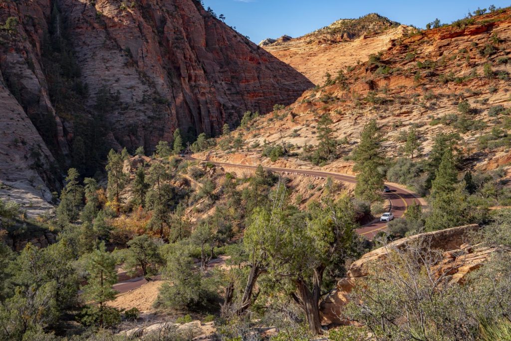
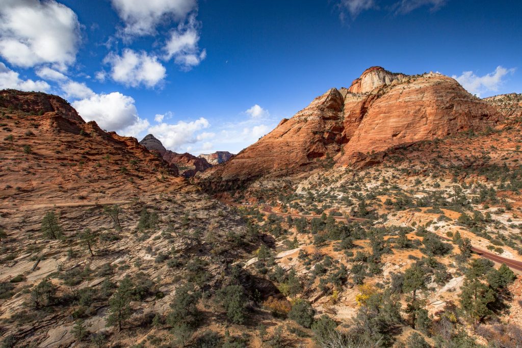
The Switchbacks
After you emerge from the east portal of the tunnel, the road begins a series of dramatic switchbacks as it climbs to the high plateau. This is where most people realize the east side of Zion is a completely different landscape than the main canyon.
The switchbacks offer incredible views back toward Pine Creek Canyon and the Great Arch of Zion (which is actually a blind arch, not a true arch, but it’s massive). You’ll pull over every 200 feet if you’re anything like me. The rock layers here are exposed in cross-section, and the colors shift from deep reds to creamy whites as you gain elevation.
There are a few small pullouts along the switchbacks, but parking is extremely limited. Get here early if you want to stop and photograph. By 10 AM in peak season, every pullout is full.
Canyon Overlook Trail

The Canyon Overlook Trail starts right at the east portal of the tunnel, and I’d argue it’s the best short hike in all of Zion National Park.
It’s just 1 mile round trip with about 163 feet of elevation gain. You can do it in 30 to 45 minutes. The trailhead parking lot holds maybe 15 cars and fills up by 8 AM in summer, so plan accordingly.
The trail follows a sandy ledge along the cliff edge with some metal handrails and carved steps in the sandstone. It ends at an overlook above Pine Creek Canyon with a direct view down to the switchbacks and the lower canyon. On a clear day, you can see all the way to the Towers of the Virgin.
For photographers, this is a sunrise spot. The east-facing overlook catches the first light beautifully, and you’ll have the trail mostly to yourself if you arrive before 7 AM. I’ve shot here dozens of times and the light never disappoints.
While you’re on this side of the park, Pine Creek Gorge Slot Canyon is also worth exploring if you’re up for something more adventurous. And for a full list of trail options, see our guide to 16 Amazing Hikes in Zion National Park.
Checkerboard Mesa

About 2 miles before the east entrance, you’ll pass Checkerboard Mesa on your right. It’s one of the most photographed geological features on the east side of the park, and for good reason.
The crosshatch pattern you see on the surface is the result of two different geological processes. The horizontal lines are ancient sand dune layers (cross-bedding in the Navajo Sandstone, laid down about 180 million years ago). The vertical lines are fractures caused by weathering and erosion over time. Together, they create a pattern that looks like someone scored the rock with a giant grid.
There’s a pullout right at the base of the mesa. Afternoon light is best for photography here because the low-angle sun catches the texture of those crosshatch lines. In flat midday light, the pattern almost disappears.
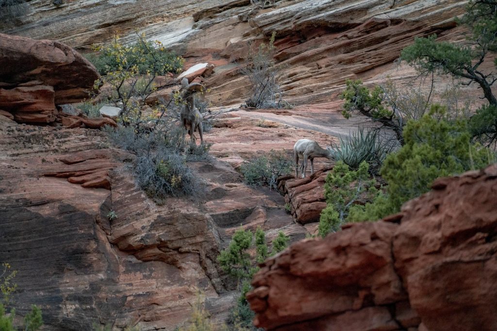
Bighorn Sheep on the Highway

The east side of Zion is prime desert bighorn sheep territory. I see them routinely near the Canyon Overlook trailhead and along the switchbacks, often standing right on the road or on the rock ledges just above it.
Drive carefully through this section. The sheep are habituated to cars but they’re still wild animals, and they will step into the road without warning. If you spot a group, pull over safely and keep your distance. A 200mm lens is plenty from the road.
Best Time to Drive the Zion-Mt. Carmel Highway

Early morning is the answer, almost any time of year. You avoid the worst of the tunnel traffic, the parking at Canyon Overlook is still open, and the light on the east side of the park is at its best before 9 AM.
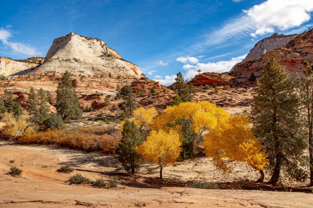
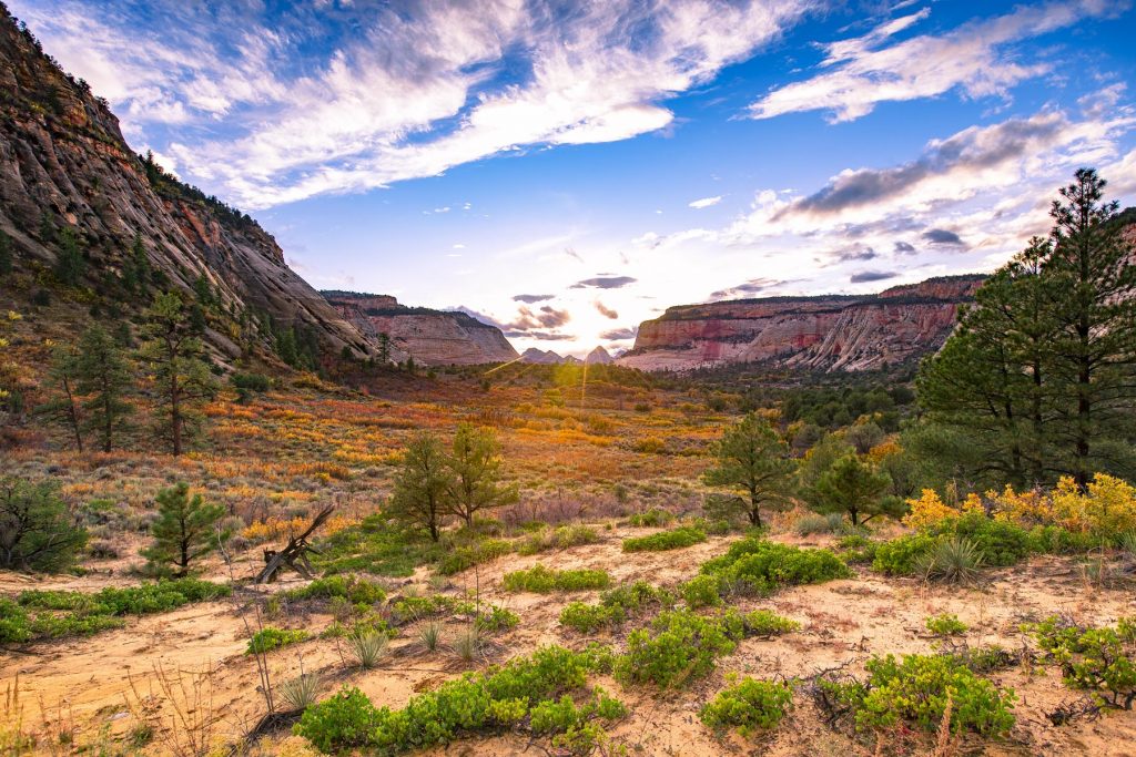
For season, autumn is my favorite. Late October through early November, the cottonwoods along the canyon floor turn blazing yellow and orange against the red sandstone. It’s one of the most photogenic moments in any national park. For more on that, check out our guide to the Best Time to Visit Zion National Park.
Spring (March through May) is also excellent. The crowds are lighter than summer, and wildflowers appear in the slickrock pockets along the east side. Summer works but the heat is intense and the tunnel delays are at their worst. Winter can be magical if the road is open, but check conditions. Snow and ice occasionally close the highway.
Photography Tips
I’ve shot this highway in every season and here’s what I’ve learned. Morning light is best for the east side, meaning the switchbacks, Checkerboard Mesa area, and Canyon Overlook. The formations face east and catch that golden early light perfectly.
For the west side near Canyon Junction, afternoon and evening light is better. The Towers of the Virgin and West Temple glow orange in the last hour before sunset.
Bring a polarizer. The Navajo Sandstone reflects a lot of light, and a polarizing filter will cut the glare and deepen the contrast between rock and sky. A wide-angle lens (16-35mm range) is essential for the switchback overlooks, and something in the 70-200mm range will serve you well for bighorn sheep and Checkerboard Mesa details.
Traffic and Logistics
A few practical things to keep in mind. The highway is open to private vehicles year-round (weather permitting). Unlike the Zion Canyon Scenic Drive, which requires the park shuttle from March through November, the Mt. Carmel Highway has no shuttle restrictions. You drive it yourself.
Traffic congestion is real, especially during peak hours (10 AM to 4 PM in summer). The limited pullout parking, bighorn sheep crossings, and tunnel escort delays all contribute. If you’re visiting during peak season, do this drive first thing in the morning or in the late afternoon.
If you’re building a multi-day trip, our Zion National Park Itinerary covers how to fit the Mt. Carmel Highway into a 1 to 5 day plan. And if you’re combining parks, the Utah National Parks Road Trip guide connects Zion to Bryce Canyon, Capitol Reef, Arches, and Canyonlands.
Other Stops on the East Side
While you’re on the east side of the park, a few more stops are worth your time. Lava Point Overlook is accessible via Kolob Terrace Road (not directly from the Mt. Carmel Highway, but worth the detour) and offers one of the highest viewpoints in the entire park at 7,890 feet. And Kolob Canyons on the north end of the park sees a fraction of the main canyon’s crowds.
For the full picture of what Zion offers, our complete guide to Zion National Park covers everything from shuttle logistics to backcountry permits.
Photos of the Zion-Mt. Carmel Highway

Zion National Park Video
ZION 8K is the culmination of nearly a month spent exploring Zion National Park during peak fall color. Filmed primarily in stunning UHD 8K.
Frequently Asked Questions About Zion National Park
When is the best time to visit Zion?
The best time to visit Zion National Park is April through October. Conditions vary significantly by season, so plan accordingly and check current conditions before your trip.
How much does it cost to enter Zion National Park?
The entrance fee for Zion National Park is $35 per vehicle (valid for 7 days). An America the Beautiful Annual Pass ($80) covers entrance to all 63 national parks and 2,000+ federal recreation sites.
What is Zion known for?
Zion National Park is known for Angels Landing, The Narrows, Emerald Pools, and Canyon Overlook Trail. The park spans 147,243 acres and was established in 1919.
What are the best things to do at Zion National Park?
The top activities at Zion include Hiking, Canyoneering, Rock climbing, Scenic drives, and Stargazing. Check our Zion guide for detailed recommendations.
Where is Zion National Park located?
Zion National Park is located in Utah. Visit our complete Zion guide for directions, nearby airports, and getting-there tips.