Arizona holds one of the longest human records in North America, and most of it is written in stone, adobe, and desert. People farmed the Gila River with hand-dug canals more than a thousand years ago. The Sinagua stacked limestone homes into cliff faces above Beaver Creek. Spanish missionaries pushed north from Sonora and left churches that still hold Mass. The U.S. Army and the Chiricahua Apache fought a long war here, and Geronimo surrendered not far from the New Mexico line. Then came the silver rush, the trading posts, and the railroad. You can stand in most of these places yourself, which is the whole point.
We’ve grouped the sites below by era, starting with the Ancestral and pre-contact cultures who were here first and ending at the Grand Canyon, which carries all of that human history at once. For each one we list what it is, who manages it, who built it, what to see, the nearest town, and a practical note. A few designations get mixed up online a lot, so we checked each one against the National Park Service, Arizona State Parks, and the sites’ own pages. Where a name is misleading, we say so.
Historic Sites In Arizona At A Glance
| Site | Nearest city | Era / significance | Managed by | Fee |
|---|---|---|---|---|
| Casa Grande Ruins National Monument | Coolidge | Hohokam Great House, ca. 1300s; first U.S. archaeological reserve (1892) | National Park Service | Free |
| Montezuma Castle National Monument | Camp Verde | Sinagua cliff dwelling, ca. 1100-1425 | National Park Service | $10 / adult |
| Tuzigoot National Monument | Clarkdale | Southern Sinagua hilltop pueblo, ca. 1100-1400 | National Park Service | $10 / adult |
| Walnut Canyon National Monument | Flagstaff | Sinagua cliff dwellings, ca. 1100s-1250 | National Park Service | $25 / vehicle |
| Wupatki National Monument | Flagstaff | Ancestral pueblos and ballcourt, ca. 1100-1250 | National Park Service | $25 / vehicle |
| Tonto National Monument | Roosevelt | Salado cliff dwellings, ca. 1300-1450 | National Park Service | $10 / person |
| Navajo National Monument | Shonto / Kayenta | Ancestral Puebloan cliff villages, ca. 1250-1300 | National Park Service (on Navajo Nation) | Free |
| Canyon de Chelly National Monument | Chinle | 5,000 years of continuous habitation; living Navajo community | NPS and Navajo Nation | Free |
| Tumacacori National Historical Park | Tumacacori / Nogales | Spanish colonial mission, founded 1691 | National Park Service | $10 / adult |
| Mission San Xavier del Bac | Tucson | Spanish colonial church, completed 1797; active parish | Catholic Diocese of Tucson / Tohono O’odham | Free |
| Hubbell Trading Post National Historic Site | Ganado | Oldest operating trading post on the Navajo Nation (1878) | National Park Service | Free |
| Fort Bowie National Historic Site | Bowie / Willcox | Apache Wars army post, 1862-1894 | National Park Service | Free |
| Tombstone Courthouse State Historic Park | Tombstone | 1882 county courthouse, silver-boom era | Arizona State Parks | $8 / adult |
| Pipe Spring National Monument | Fredonia | Kaibab Paiute lands and 1870s Mormon fort | National Park Service | Free |
| Grand Canyon National Park | Grand Canyon Village | Human history spanning 12,000 years; eleven associated tribes | National Park Service | $35 / vehicle |
The First Builders: Hohokam, Sinagua, Salado, And Ancestral Puebloan
Casa Grande Ruins National Monument
Casa Grande is the place to start, both for the history and for what it represents. The four-story earthen “Great House” was raised by the Hohokam around the 1300s, the same people who engineered hundreds of miles of irrigation canals across the Salt and Gila river valleys. Nobody is certain what the building was for. An astronomical calendar, a community hall, a watchtower. The walls are caliche mud, and they have stood in the open desert for roughly seven centuries.
What makes the site matter beyond the structure itself is the year 1892. President Benjamin Harrison set aside 480 acres here as the first archaeological reserve in the United States, more than a decade before the Antiquities Act existed. The fight to protect Casa Grande helped create the entire idea of federal protection for cultural sites. A steel canopy built in 1932 now shades the Great House, which is worth seeing on its own as early preservation architecture.
109 public lands destinations are under threat. Get the free weekly briefing that 25,000+ people use to stay informed and take action.
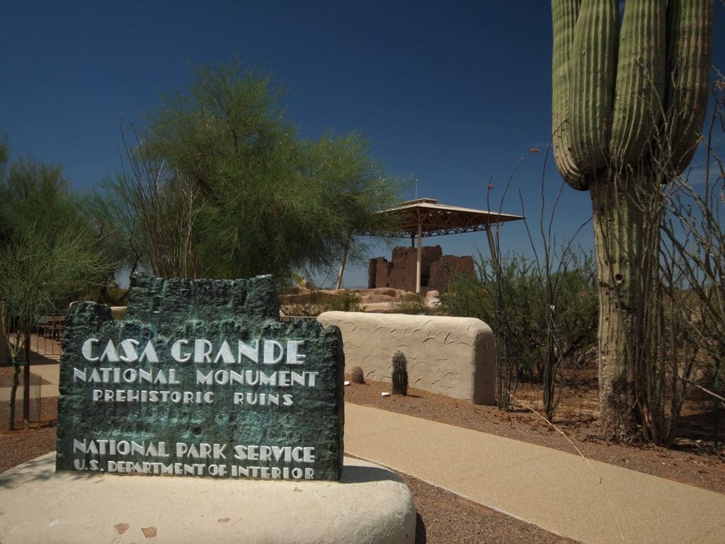
What to see: The Great House up close, the surrounding compound walls, and the small museum on Hohokam canal engineering. Nearest city: Coolidge, about an hour southeast of Phoenix. Practical note: Entry is free. Go early in the day from May through September, when afternoon temperatures regularly clear 105 degrees and the open site offers almost no shade.
Montezuma Castle National Monument
First, the name is wrong, and the Park Service will tell you so. Early Anglo settlers assumed this five-story cliff dwelling had something to do with the Aztec emperor Montezuma. It did not. The Sinagua built it, and they abandoned it around 1425, roughly a century before Montezuma was born. The misnomer stuck anyway.
What’s actually here is one of the best-preserved cliff dwellings in the Southwest, a 20-room apartment tucked into a limestone alcove about 90 feet above the floodplain of Beaver Creek. You view it from the paved loop below rather than entering it, which keeps the fragile structure intact. The shade of the sycamores along the creek makes this one of the more comfortable archaeological sites to visit in summer.
What to see: The cliff dwelling from the creekside trail, plus Montezuma Well, a separate unit 11 miles away where a natural limestone sinkhole feeds Sinagua irrigation ditches that still carry water. Nearest city: Camp Verde, off I-17 between Phoenix and Flagstaff. Practical note: The $10 adult fee also covers Tuzigoot for seven days, so pair the two. Montezuma Well is free.
Tuzigoot National Monument
Where Montezuma Castle goes vertical, Tuzigoot spreads out. This is a Southern Sinagua pueblo built on a ridge above the Verde River, a 110-room complex that grew room by room between about 1100 and 1400. From the top you look out over Tavasci Marsh and the old copper-mining town of Clarkdale, which gives you the whole arc of the valley’s history in one view.
The pueblo was excavated in the 1930s as a Depression-era work project, and the trail loops right through the rooms rather than holding you at a distance. Walking the masonry walls at eye level gives you a far better sense of how these people actually lived than a roped-off overlook does.
What to see: The ridgetop pueblo, the reconstructed rooftop room you can enter, and the museum’s Sinagua pottery and shell jewelry traded up from the Gulf of California. Nearest city: Clarkdale, near Sedona and Cottonwood. Practical note: The third-mile loop trail is short and partly shaded, but the hilltop is exposed. The $10 ticket is shared with Montezuma Castle.
Walnut Canyon National Monument
Just east of Flagstaff, the Sinagua built their homes into the canyon walls themselves, slotting masonry rooms under natural limestone overhangs. The Island Trail drops about 185 feet down a series of stairs and runs you right past 25 cliff dwelling rooms, close enough to touch the soot still on the ceilings. It is one of the few places in Arizona where you actually walk through the dwellings rather than looking at them from across a gorge.
The descent is the catch. You climb back up those 185 feet at 6,690 feet of elevation, which surprises a lot of visitors coming from sea level. Take it slow. The Rim Trail is an easy flat alternative with overlooks if the stairs are too much.

What to see: The Island Trail cliff rooms and the canyon-rim overlooks. Nearest city: Flagstaff, ten minutes west off I-40. Practical note: The $25 vehicle pass covers Walnut Canyon, Wupatki, and Sunset Crater Volcano, the three Flagstaff Area monuments, for seven days. Snow can close the Island Trail in winter.
Wupatki National Monument
Wupatki sits in open red-rock country north of Flagstaff, and it tells a more complicated story than a single culture. After the nearby Sunset Crater volcano erupted around 1085, people moved into this area and built pueblos that show influences from Ancestral Puebloan, Sinagua, and Cohonina traditions all at once. The main pueblo holds about 100 rooms and includes a masonry ballcourt, the northernmost one known, which links these communities to a much wider trade world reaching into Mesoamerica.

There is also a geological oddity here worth timing your visit for. A natural blowhole next to Wupatki Pueblo breathes air in and out depending on barometric pressure, sometimes hard enough to feel on your hand. The tribes who descend from these builders, including the Hopi, regard the site as ancestral and very much alive.
What to see: Wupatki Pueblo, the ballcourt, the blowhole, and the smaller Wukoki and Citadel pueblos along the loop road. Nearest city: Flagstaff, via the 35-mile loop road it shares with Sunset Crater. Practical note: Covered by the $25 Flagstaff Area pass. The loop has no services and no water, so fill up before you go.
Tonto National Monument
Above Roosevelt Lake, two cliff dwellings look out over what is now the Tonto Basin. The people who built them, between roughly 1300 and 1450, are known to archaeologists as the Salado, a blend of local and immigrant groups who shared a distinctive polychrome pottery style. Their woven cotton textiles, preserved in the dry alcoves, are some of the finest surviving examples of the period anywhere in the Southwest.

You can reach the Lower Cliff Dwelling on your own, a one-mile round trip that climbs about 350 feet through saguaro and jojoba. The Upper Cliff Dwelling is larger and only open by ranger-guided tour, offered on a reservation basis in the cooler months. The guided hike is worth planning around if your dates line up.
What to see: The Lower Cliff Dwelling, the visitor center’s Salado pottery and textiles, and the basin views. Nearest city: Roosevelt, on the Apache Trail east of Phoenix. Practical note: The $10 per-person fee is cashless only. The trail is exposed and steep, so summer mornings only.
Navajo National Monument
The name causes confusion, so it’s worth being precise. The monument sits on the Navajo Nation, but the cliff villages it protects were built by the Ancestral Puebloan people around 1250 to 1300, ancestors of today’s Hopi, Zuni, and other Pueblo nations rather than of the Navajo. The Park Service has moved away from the older term “Anasazi,” a Navajo word, in favor of Ancestral Puebloan, which the descendant communities prefer.
Three villages sit within the monument: Betatakin, Keet Seel, and Inscription House. Betatakin is visible from the Sandal Trail overlook, a 1.3-mile paved round trip anyone can do. Reaching the dwellings up close takes commitment. Keet Seel requires a ranger-led backcountry hike of about 17 miles round trip and a permit, and it rewards you with one of the best-preserved cliff villages on the continent.
What to see: The Betatakin overlook from the Sandal Trail, the visitor center exhibits, and the ranger tours to Betatakin or Keet Seel in summer. Nearest city: Kayenta, off US-160 in the far northeast. Practical note: Entry is free. Guided tours run seasonally and book up, so call ahead.
Canyon de Chelly National Monument
Canyon de Chelly is different from every other site on this list because Navajo families still live and farm on the canyon floor. People have occupied these red sandstone walls for nearly 5,000 years, from Ancestral Puebloan cliff dwellings like the White House to the Navajo hogans and peach orchards of today. It is co-managed by the Park Service and the Navajo Nation, and that partnership shapes how you visit.
You can drive the North and South Rim roads and stop at overlooks on your own for free, including the famous view of Spider Rock, an 800-foot sandstone spire. But to go down into the canyon, you need an authorized Navajo guide, with one exception: the White House Ruin Trail, a 2.5-mile round trip you can hike without a permit. Hiring a guide is the right call anyway. This is a living community, and a Navajo guide gives you the history that no wayside sign can.
What to see: The Spider Rock overlook, the White House Ruin Trail, and a guided canyon-floor tour by vehicle or horseback. Nearest city: Chinle, on the Navajo Nation. Practical note: Entry is free, but guides are not, and arranging one is part of the visit. Be respectful of residents and do not photograph people or homes without permission.
The Spanish Missions
Tumacacori National Historical Park
The mission of San Jose de Tumacacori sits in the Santa Cruz River valley south of Tucson, and the half-finished church at its center tells a hard story. The Jesuit missionary Eusebio Kino first visited the O’odham community here in 1691. Franciscans later began the large adobe church you see today, but they never completed it. Apache raids, Mexican independence, and finally an order expelling Mexican priests left the mission abandoned by the 1840s, the church bare and roofless.
That unfinished quality is exactly what makes it worth seeing. You walk through the weathered nave, the sanctuary, and the cemetery, with faint traces of original paint still on the plaster. The park preserves the ruins rather than restoring them, so you see the mission as time left it.
What to see: The mission church and grounds, the museum, and the orchard garden. Living-history demonstrations and full-moon evening tours run on a schedule. Nearest city: Tumacacori, about 45 minutes south of Tucson near Nogales. Practical note: $10 per adult, good for seven days. Guided tours run in the cooler months.
Mission San Xavier del Bac
One designation note before anything else. San Xavier is not a National Park Service site. It is an active Catholic church on the Tohono O’odham Nation, run by the Diocese of Tucson, and people attend Mass here every week. That living use is part of why the “White Dove of the Desert” feels so different from the mission ruins down the road.
Father Kino founded the mission at this O’odham settlement in 1692. Franciscans built the current church between 1783 and 1797, which makes it the oldest intact European building in Arizona. The interior is the reason to come: a dense program of painted statues, frescoes, and carved retablos, much of it conserved in recent decades by the same specialists who work on European cathedrals. It is one of the finest examples of Spanish Colonial architecture in the country.
What to see: The painted interior, the two bell towers (one famously left unfinished), and the hilltop grotto across the plaza. Nearest city: Tucson, about ten miles south of downtown. Practical note: Free, donations welcome. It is a working church, so check the Mass schedule and dress and behave accordingly.
Frontier Arizona: Trading Posts, The Apache Wars, And The Silver Boom
Hubbell Trading Post National Historic Site
Hubbell Trading Post is not a museum about a trading post. It is a trading post, still operating, the oldest one continuously running on the Navajo Nation. John Lorenzo Hubbell bought the business in Ganado in 1878, ten years after the Navajo returned from their forced exile at Bosque Redondo, and his family ran it until they sold it in the 1960s. The Western National Parks Association keeps it going today much as it always was.
That continuity is the whole experience. You can buy a Navajo rug or a piece of silverwork off the same worn wooden counters where the trade has happened for nearly 150 years, with weavers and silversmiths often selling directly. The rug room alone, stacked floor to ceiling, is worth the drive.
What to see: The working trading post and rug room, the Hubbell family home on ranger-led tours, and demonstrations by Navajo weavers. Nearest city: Ganado, on the Navajo Nation east of Window Rock. Practical note: Entry is free. Buying directly supports Navajo artists, which is the point of the place.
Fort Bowie National Historic Site
Fort Bowie guarded Apache Pass and Apache Spring, the only reliable water for miles and the flashpoint of a war that ran for a quarter century. The army built the post in 1862 after the Bascom Affair, the 1861 standoff in which a young lieutenant’s blunder turned the Chiricahua leader Cochise against the United States. The fort stood at the center of the campaigns against Cochise and later Geronimo until the Apache Wars ended in 1886.

Reaching it takes effort, and that’s deliberate. There is no road to the fort. You walk a 1.5-mile trail in (3 miles round trip) past the ruins of the Butterfield stage station, the post cemetery, and Apache Spring itself, which puts you in the landscape the way the soldiers and the Apache experienced it. The walk is the experience as much as the adobe ruins at the end.
What to see: The trail past the stage station and cemetery, the fort ruins, and the visitor center’s exhibits on the Apache Wars. Nearest city: Bowie or Willcox, off I-10 in southeastern Arizona. Practical note: Free, but remote, with a graded dirt access road and no water on the trail. Carry plenty and avoid the midday heat.
Tombstone And The Tombstone Courthouse State Historic Park
Tombstone is worth understanding for what it is and is not. The town is a silver-boom settlement that exploded after Ed Schieffelin struck ore in 1877, and the 30-second gunfight near the O.K. Corral on October 26, 1881 made it permanently famous. Today most of the attractions on Allen Street, including the O.K. Corral reenactment and the Bird Cage Theatre, are privately run businesses, not public historic sites. They are fun, but they are commercial.
The genuine public historic site is the Tombstone Courthouse, an 1882 red-brick Victorian building that served Cochise County until 1931. It is an Arizona State Historic Park now, with one of the better museums in the state on the silver era, frontier law, and the gunfight, told with actual artifacts rather than actors. If you want the history straight, start here.
What to see: The restored courtroom, the sheriff’s office and gallows out back, and the mining and gunfight exhibits. Nearest city: Tombstone itself, southeast of Tucson near Sierra Vista. Practical note: The courthouse charges about $8 per adult through Arizona State Parks. Budget separately for the privately run attractions if you want the reenactments.
Pipe Spring National Monument
Out on the lonely Arizona Strip, north of the Grand Canyon and hard against the Utah line, Pipe Spring holds two histories at the same spring. The Kaibab Paiute have relied on this water for centuries, and the monument sits within their reservation. In 1870 the Mormon Church built a fortified stone ranch house over the main spring, called Winsor Castle, to run a tithing herd of cattle. The fort went up directly on top of the water the Paiute depended on, and that tension is the story the site now tells honestly from both sides.
It is far from everything, which is part of the appeal. The fort is preserved with period furnishings, costumed interpreters work the ranch in season, and the museum is run jointly with the Kaibab Paiute Tribe. If you are driving between the Grand Canyon’s North Rim and Zion, it makes a worthwhile stop.
What to see: Winsor Castle on a guided tour, the garden and longhorn cattle, and the tribal museum. Nearest city: Fredonia, near Kanab, Utah. Practical note: Entry is free. It is genuinely remote, so plan fuel and food around the visit.
Grand Canyon National Park, Where The Human Story Comes Together
We are More Than Just Parks, but the Grand Canyon belongs on any honest list of Arizona’s historic sites, because human history runs all the way through it. People have lived in and around the canyon for around 12,000 years. Ancestral Puebloan granaries still cling to ledges along the river, and eleven tribes maintain ancestral and ongoing ties to the canyon today, including the Havasupai and Hualapai, whose lands border and reach into it.

The built history is here too, much of it dating to the early park era. The Desert View Watchtower, designed by Mary Colter in 1932, draws directly on Ancestral Puebloan architecture and shelters murals by Hopi artist Fred Kabotie. The historic lodges along the South Rim, the old Santa Fe Railway depot, and the tribal stories told at Tusayan Ruin all turn a scenic overlook into a place you can read like a document. For the full landscape, our deeper guide to Grand Canyon National Park covers the rims, the trails, and the logistics.
What to see: Desert View Watchtower and Drive, the Tusayan Ruin and museum, the historic South Rim village, and the Hopi House. Nearest city: Grand Canyon Village on the South Rim, or Flagstaff and Williams as bases. Practical note: $35 per vehicle for seven days, covering both rims. The North Rim closes for winter; the South Rim stays open year-round and gets crowded, so arrive early.
Planning Your Arizona History Trip
These sites cluster into a few natural loops. The Verde Valley pairs Montezuma Castle and Tuzigoot on one ticket near Sedona. Flagstaff puts Walnut Canyon, Wupatki, and Sunset Crater within an hour of each other on a single vehicle pass. Southern Arizona links Tumacacori, San Xavier, Tombstone, and Fort Bowie around Tucson. The far northeast, on the Navajo Nation, holds Canyon de Chelly, Navajo National Monument, and Hubbell Trading Post, with the most driving between them.
A few honest cautions. Summer afternoons in the desert lowlands are dangerous, not just uncomfortable, so do the exposed sites early and carry more water than you think you need. Fees and tour schedules change, especially the guided programs at Tonto, Navajo, and Canyon de Chelly, so confirm before you drive hours to get there. And on tribal lands and at active churches, you are a guest. Ask before photographing people, and follow the posted rules. Get those things right and Arizona will give you a clearer view of the American past than almost any state can.
We don’t make this stuff up. We’ve spent our adult lives exploring and filming America’s national parks and public lands destinations, working with the National Park Service, the Department of the Interior, the USDA, and the U.S. Forest Service on films about places like these. You can see that work on our films page.
Related Reading
- Arizona National Parks: a full guide to the 24 national park sites across the state.
- USA National Parks: our complete list of every national park in the country.
- Civil War Sites and Revolutionary War Sites: more history-focused roundups.