Death Valley is 5,270 square miles. Hottest place on earth. Lowest point in North America. Driest place in the United States. Driving from one end to the other takes nearly 5 hours.
Death Valley National Park Map
7 places to explore — click a pin to learn more
Death Valley National Park at a Glance
1 alertFolks who tell you there isn’t much to do here aren’t your friends.
We’ve spent more time in Death Valley than almost any other park over the past decade. Here are the best things to do, organized by area so you can actually plan your days, starting with the stuff closest to where most folks set up camp.
Death Valley holds the record as the hottest place on earth, the record for the lowest point in North America, and the driest place in the United States. Driving from one end to the other takes nearly 5 hours. The $30 entrance fee is good for 7 days, so don’t buy a new pass if you’re making multiple visits.
- Here’s our favorite guidebook & map for Death Valley.
- Lather up the non-toxic sunscreen.
- Cell service is essentially nonexistent throughout most of the park. Download offline maps before you leave your hotel. This is not optional. We mean it.
- Bring more water than you think you need. We carry a minimum of one gallon per person per day and have still run low.
- Best time to visit: October through April. Summer temperatures regularly exceed 120 degrees F and can be genuinely dangerous.
- Gas stations are rare. Fill up before entering the park. Furnace Creek and Stovepipe Wells have gas but prices are steep.
Where to Get Gas, Food, and Water
Death Valley has three places to resupply and that’s it. Plan accordingly.
Furnace Creek Gas station, general store, two restaurants, lodging. Open year-round. This is home base for most folks.
Stovepipe Wells Gas station, small store, restaurant, campground. Open year-round but limited hours in summer.
Panamint Springs Gas station, small restaurant. On the western edge of the park along Highway 190. Limited hours.
Gas prices inside the park run $2-3 more per gallon than outside. Fill up in Beatty, Lone Pine, or Las Vegas before you enter.
Related: Pleasant Valley
One Day in Death Valley
Sunrise at Zabriskie Point. Drive to Badwater Basin before it gets hot. Artists Palette on the way back. Mesquite Flat Sand Dunes at sunset. That’s a full day and you’ll hit four of the park’s best spots without killing yourself.
Two Days in Death Valley
Day 1: Same as above. Day 2: Darwin Falls in the morning (it’s shaded). Wildrose Charcoal Kilns midday. Drive up to Ubehebe Crater in the afternoon. If you have a 4WD and an adventurous streak, push on to Racetrack Playa but budget 6 hours for the round trip from Ubehebe.
Three or More Days
Now you’re talking. Days 1-2 same as above. Day 3: Eureka Dunes. This is the bucket list item but it’s a 3-hour drive from Furnace Creek on rough roads. Worth every minute. If you have a week, add Telescope Peak (the park’s highest point, 14 miles RT), Surprise Canyon, and the Ibex Dunes at sunrise.
Visiting Death Valley? Here’s our favorite hotel to stay in Death Valley National Park
Sunrise at Zabriskie Point is the single best photography opportunity in the park. Get there 30 minutes before dawn to claim a spot. The golden badlands light up like they are on fire for about 15 minutes, then it is over.
Furnace Creek Area (Central Valley)
This is where most folks start and where most of the classic Death Valley sights live. Everything here is off Badwater Road or a short drive from Furnace Creek. You can knock out all of these in a single day if you start early.
1. Sunrise from Zabriskie Point
Distance Short paved walk to overlook; 2.5 mi RT into badlands Time 30 min-2 hrs Difficulty Easy-Moderate Vehicle Any car Drive from Furnace Creek 5 min
Watching a sunrise at Zabriskie Point is one of the most iconic things to do in all of Death Valley National Park. This location is our second favorite place in the park to watch a sunrise (more on our favorite in a minute). The badlands below, formed by millions of years of erosion, showcase a mesmerizing palette of yellows, browns, and purples.
As one of Death Valley’s most popular locations, crowds here can be large. Show up 30 minutes to an hour before sunrise to get a good spot. There is a short, steep paved pathway from the parking lot to the viewpoint.
Elevation: 5,744 feet (bring a jacket, it’s much cooler than the valley floor)
Parking: Moderate lot. Fills up before sunrise on weekends. Plan accordingly.
Named after: Christian Brevoort Zabriskie, a vice president of the Pacific Coast Borax Company
Here’s our hot take. Skip the main Zabriskie viewpoint and walk 5 minutes down the trail into the badlands themselves. The perspective from below, looking up at those eroded ridges as the first light hits them, is far more dramatic than the standard overlook shot everyone posts on Instagram. Most people don’t bother. Their loss.
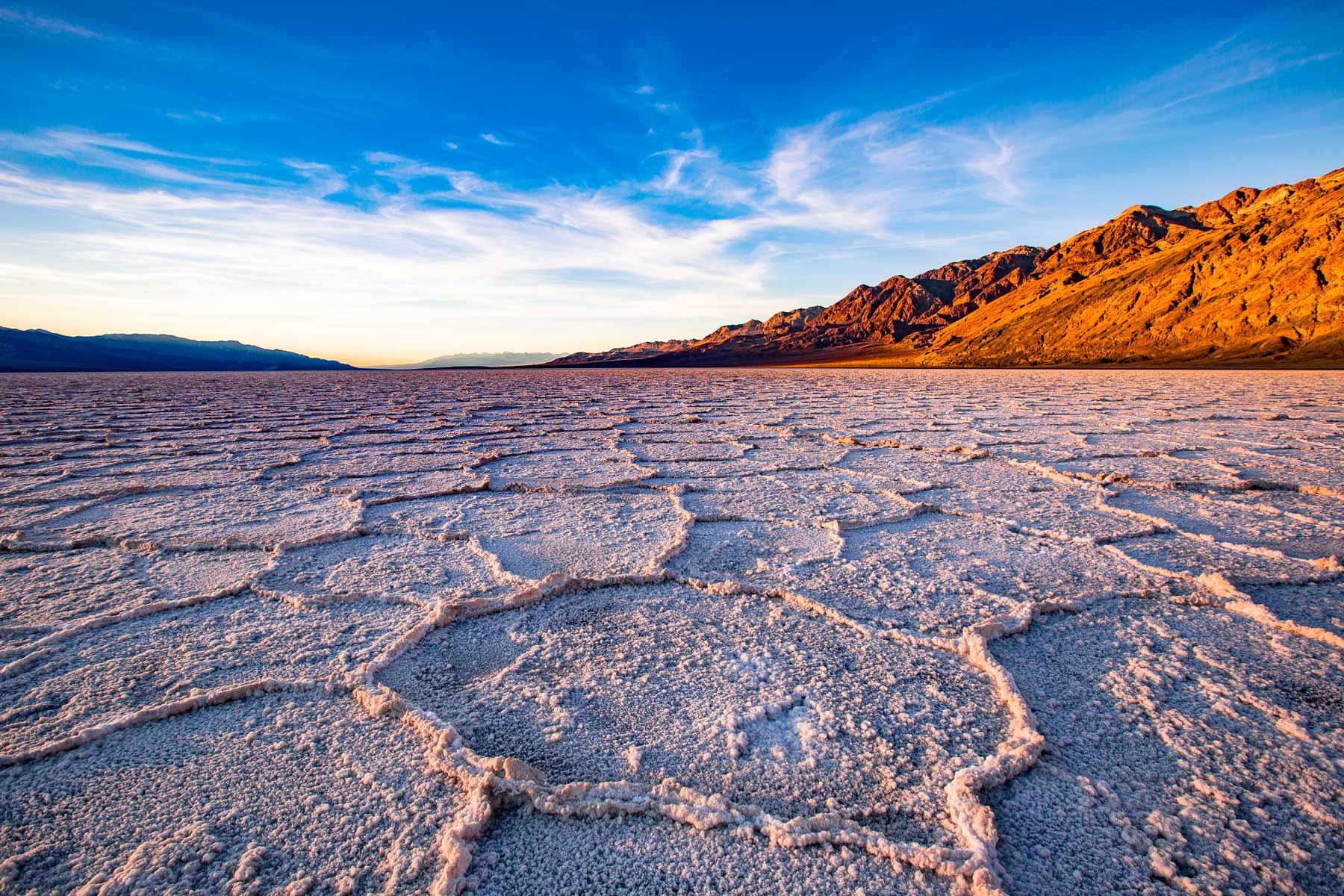
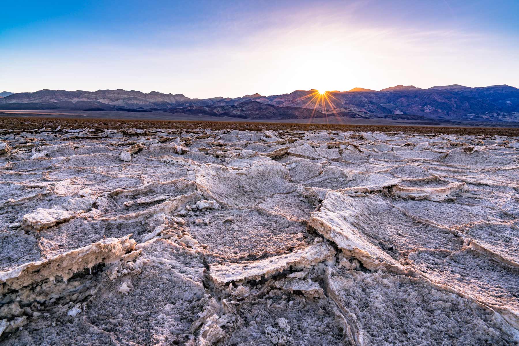
2. Explore Badwater Basin
Distance 1 mi RT boardwalk + optional salt flat walk Time 30 min-1 hr Difficulty Easy Vehicle Any car Drive from Furnace Creek 25 min
At 282 feet below sea level, Badwater Basin is the lowest point in North America, reason alone to visit. This salty wonderland features dazzling geometric shapes and has record temperatures in the summer. Badwater Basin is one of the best things to do in Death Valley with kids as well as folks looking for convenient ADA activities.
Park at the Badwater Basin lot (get there early as parking is limited) and walk across a wooden boardwalk into the salt flats. Read the informative plaques at the start of the hike to learn about the lifeforms that thrive in this desolate landscape.
Tip: Most folks just hike out a few steps beyond the short boardwalk but to truly get a sense of the scale of the salt flats you can do the entire 1.8-mile path. We recommend going at least 15 minutes out. That’s where the salt formations get really wild and the crowds thin out completely.
Parking: Small lot fills by mid-morning. Arrive before 9am.
Best time: Sunset. The colors on the salt flats and the mountains behind them are something else entirely.

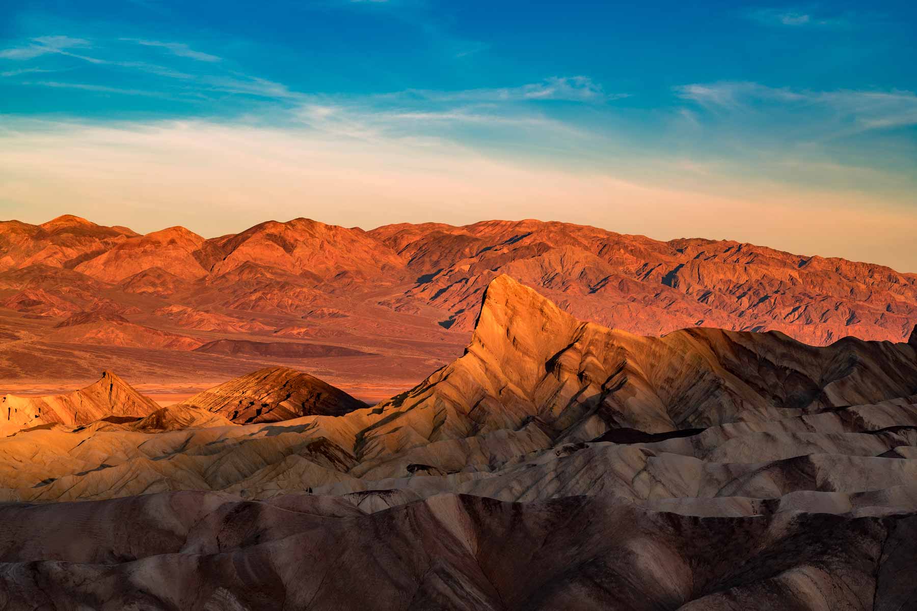
3. See the Kaleidoscopic Cliffs at Artists Palette
Distance 9 mi scenic drive Time 30 min-1 hr Difficulty Easy Vehicle Any car Drive from Furnace Creek 15 min
When we first saw photos of Artists Palette we thought it must be Photoshop. Surely the cliffs don’t actually look like that in person, right? Wrong. They do. But not at all times of day. Artists Palette is a technicolor, kaleidoscopic display of multicolored rock that must be seen to be believed.
The vibrant colors are caused by the oxidation of different metals in the rock. Iron oxides produce reds, pinks, and yellows, while manganese minerals create lavender and purple hues. The decomposition of tuff-derived mica adds green tones to the palette.
The best time to visit Artists Palette is in the evening when temperatures are cooler and the sun hits the rocks just so to really make their colors pop. Harsh midday sun mutes the vivid colors. Come on a rare cloudy day if you can. The overcast light makes the colors pop even more than golden hour.

4. Walk Under Natural Bridge
Distance 2 mi RT Time 1-2 hrs Difficulty Easy-Moderate Vehicle Any car Drive from Furnace Creek 20 min
Seeing Natural Bridge is a great activity at Death Valley to get out of the sun. The bridge itself is a 35-foot-tall and 35-foot-thick archway carved by flash floods over thousands of years. This is a great daytime hike to avoid direct sun by walking on the shadowy side of the canyon.
Parking: Small dirt lot off Badwater Road
Tip: Once you get to the bridge, the view back down the canyon gives you a great view of the valley in the distance. Worth turning around for.
5. Play a Round at the Devils Golf Course
Distance Short walk from pulloff Time 20-30 min Difficulty Easy Vehicle Any car Drive from Furnace Creek 20 min

Death Valley is the king of things with morbid and foreboding names. Devils Golf Course is many park-goers’ favorite spot in the whole park. The name comes from a 1934 National Park Service guidebook that described the terrain as so uneven and treacherous that “only the devil could play golf on it.”
The entire area is covered in large, crystallized halite salt formations, the remnants of an ancient lake bed that dried up thousands of years ago. These salt formations are constantly being eroded by wind and rain, creating new and ever-changing shapes. If you’re quiet and listen closely on a hot day, you can actually hear the salt crystals popping and expanding. It’s one of the weirdest sounds in nature.
NOTE: The salt formations are delicate and can be easily damaged by human touch. Stay on the designated paths and avoid walking on the salt crystals.

6. Sunrise at Aguereberry Point
Distance Short walk from parking Time 30 min Difficulty Easy Vehicle High-clearance recommended Drive from Furnace Creek 45 min
While the most popular sunrise spot in Death Valley is Zabriskie Point, if you want to see the most spectacular (says us) sunrise in the park you’ll have to cross the valley and view it from the other side at Aguereberry Point.
Perched at an elevation of 6,433 feet, Aguereberry Point offers stunning panoramic views of the vast desert landscape, comparable to the popular Dante’s View on the opposite side of the valley. Whereas Zabriskie and Dante’s face away from the sun, Aguereberry Point looks directly at it creating a more dazzling display of colors and light to usher in the day.
Crowds: Almost none. When we visited we were the only ones there versus Zabriskie which is always packed.
Named after: Jean Pierre “Pete” Aguereberry, a French miner who discovered gold nearby and lived here from 1905 until his death in 1945. Remnants of his cabin and the Eureka Mine are still visible.
7. Dante’s View
Distance Short walk from parking Time 30 min-1 hr Difficulty Easy Vehicle Any car Drive from Furnace Creek 25 min
Dante’s View sits at 5,475 feet and gives you one of the widest panoramas in the park. You can see Badwater Basin directly below, the Panamint Range across the valley, and on a clear day, both the highest point (Telescope Peak at 11,049 feet) and the lowest point (Badwater at -282 feet) in the same view. That’s an 11,000-foot elevation swing you can take in without moving your feet.
The drive up is paved and any car can make it. Get there for sunrise or sunset. Midday is fine for the view but the light is flat and uninteresting for photos. It’s noticeably cooler up here than the valley floor so bring a layer.
Stovepipe Wells Area (Northern Valley)
About 30 minutes northwest of Furnace Creek. Stovepipe Wells has its own gas station, campground, and a handful of rooms. The dunes here are the most accessible in the park.

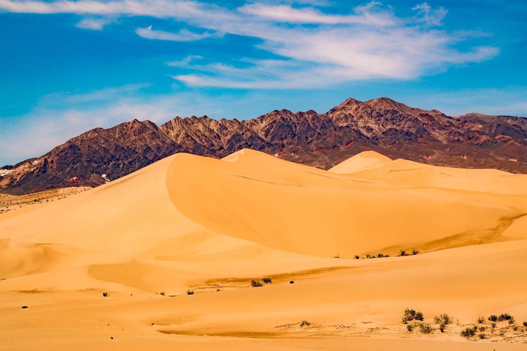
8. Play in Mesquite Flat Sand Dunes
Distance Varies, 1-3 mi Time 1-2 hrs Difficulty Easy-Moderate Vehicle Any car Drive from Furnace Creek 30 min
Visiting Mesquite Flat Sand Dunes is on just about everyone’s list of things to do in Death Valley so expect crowds. Don’t let that deter you though. Mesquite Flat Sand Dunes is the most popular of the five dune fields in the park and totally worth a visit. The tallest dunes reach around 400 feet (122 meters), offering impressive panoramic views from the summit.
Located next to Stovepipe Wells village, these dunes are an easy stop. Layer up with sunscreen before hiking onto the dunes and bring plenty of water. There is no natural cover from the sun and the sand can be extremely hot to the touch so wear closed-toe shoes during the day.
Parking: Lot on Highway 190 near Stovepipe Wells
Best time: Sunrise for photographers. The ripple patterns in the sand are sharpest before anyone else walks on them.
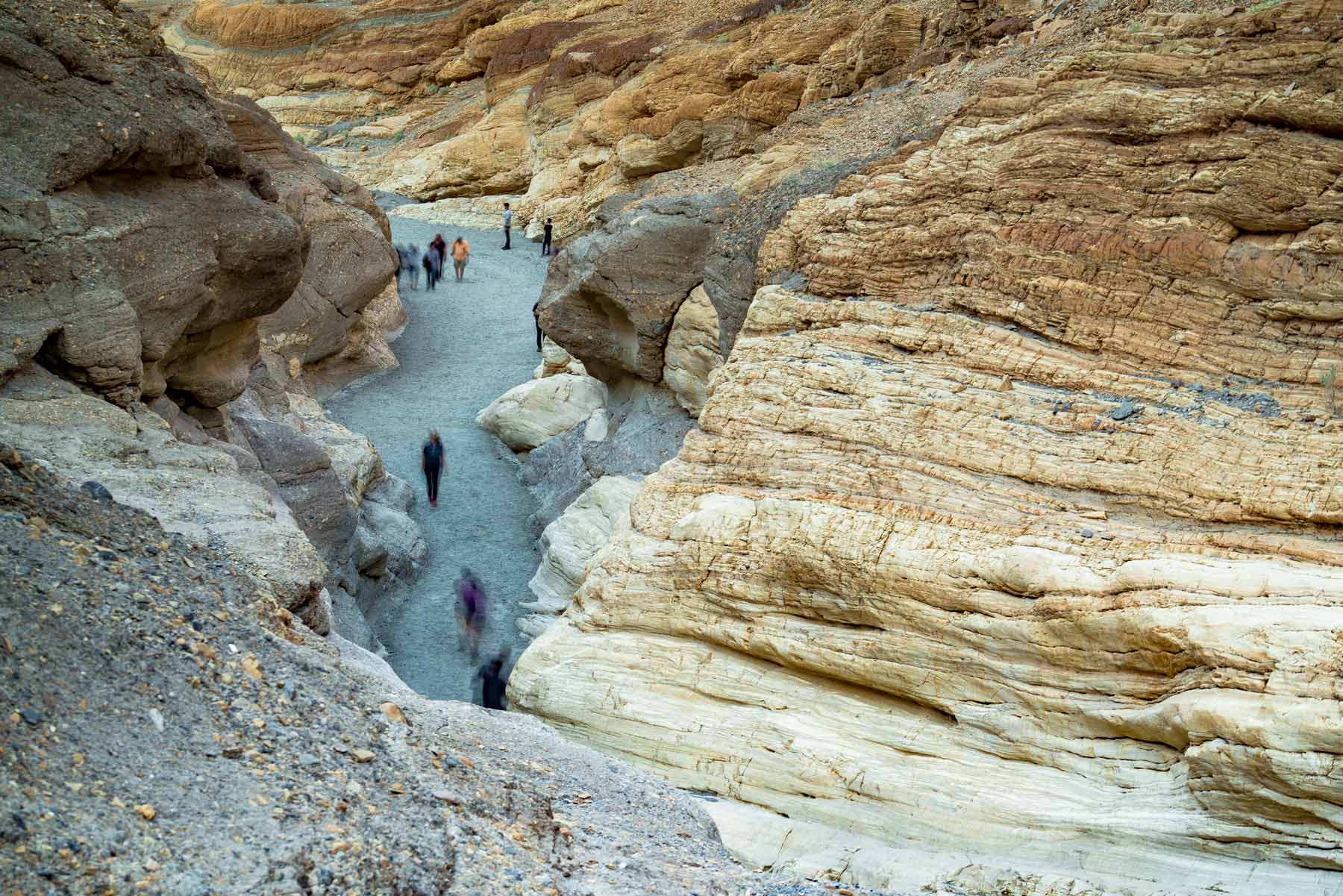
9. Marble Canyon
Distance 2-4 mi RT recommended Time 1-3 hrs Difficulty Easy-Moderate Vehicle Any car Drive from Furnace Creek 35 min
The hike through Marble Canyon is a great daytime activity on a hot day as there is typically ample shade and cooler places to rest. The canyon walls are composed of colorful marble ranging from white and green to pink and purple. These vibrant hues are a result of various minerals, including iron oxide and manganese.
The entire trail is extremely long at about 31 miles so we recommend just walking a mile or two into the canyon and then picking a point to turn around. Pack plenty of water even though there’s shade.
10. Mosaic Canyon
Distance 4 mi RT Time 1.5-2.5 hrs Difficulty Moderate Vehicle Any car (short gravel road to trailhead) Drive from Furnace Creek 30 min
Mosaic Canyon is one of those spots that doesn’t show up on most lists but probably should. The first quarter mile of the trail takes you through narrow, polished marble walls that look like they were smoothed by hand. The “mosaic” name comes from the breccia rock formations where fragments of different-colored stone got cemented together into natural mosaics millions of years ago.
The trailhead is just off the road near Stovepipe Wells. The first section through the narrows is easy and flat. Past the narrows, you’ll scramble over dry waterfalls and the canyon opens up. Most folks turn around at the 2-mile mark but you can keep going if you want solitude.
Scotty’s Castle / Northern Park
The northern section of the park is remote and worth the drive. Scotty’s Castle has been closed since a 2015 flood, though limited “Flood Recovery Tours” began in January 2026 ($35/person, select Sundays only). The grounds remain closed as part of a $90M restoration project. The real draws up here are volcanic craters and the Racetrack.
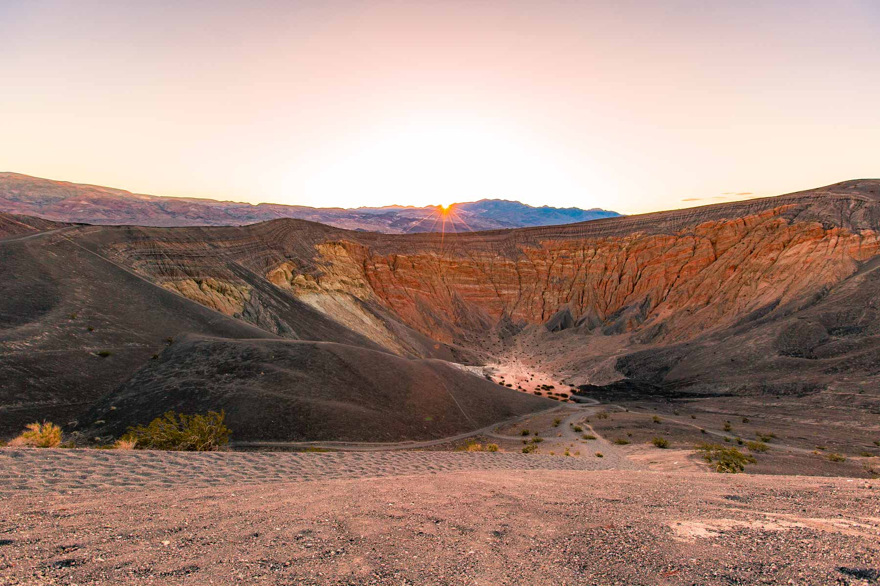
11. Gaze Upon Ubehebe Crater
Distance 2.2 mi RT rim trail Time 1-2 hrs Difficulty Moderate Vehicle Any car Drive from Furnace Creek 1.5 hrs
Ubehebe Crater, pronounced “YOU-BE-HE-BE”, was not created by a meteor strike but rather volcanic activity. Located toward the northern end of the park, this site is a great Death Valley activity for families with kids.
Ubehebe is a half-mile wide behemoth, formed by a phreatic explosion (molten lava meeting groundwater) and has vibrant hues of reds and oranges in its exposed layers. Hike the rim for panoramic views or venture down (prepare for a challenging climb back!) to feel the crater’s immensity.
Parking: Paved lot at the crater rim
Make sure to visit Little Ubehebe Crater (see below) while you’re here. Many folks, us included, find it more photogenic than its larger namesake.

12. Explore Little Hebe Crater
Distance Less than 1 mi from Ubehebe parking Time 30-45 min Difficulty Easy Vehicle Any car Drive from Furnace Creek 1.5 hrs
A lot of folks don’t even know that Ubehebe Crater has a sibling so it often gets totally overlooked. Personally, we find Little Hebe to be the more interesting of the two. Unlike Ubehebe’s maar origin (formed by a phreatic explosion), Little Hebe is a spatter cone, built up by the accumulation of ejected lava fragments during eruptions.
Getting there: Start at the Ubehebe parking lot and follow the rim trail to the right. Less than a mile walk on a nice path. Treat this as a built-in add-on to your Ubehebe visit.

13. Watch the Mysterious Rocks at Racetrack Playa
Distance Flat walk on playa Time 1-2 hrs at playa + 3 hr drive each way Difficulty Easy walk, rough drive Vehicle High-clearance 4WD required Drive from Furnace Creek 3 hrs
The Racetrack Playa features rocks that mysteriously move across the cracked desert floor leaving long trails and lots of intrigue. The rocks vary in size from a few pounds to hundreds of pounds, and their trails can extend for hundreds of feet.
In recent years, researchers are pretty certain that the movement comes from a combination of rare flooding events and thin ice sheets. Mystery solved? Maybe. But standing there watching the trails disappear toward the horizon is still eerie in the best way.
Services: None. Pack food, water, snacks for a full day. No cell service.
Time needed: Full day trip
Damage to Racetrack Playa
This location is special and sadly has not always been treated as such. In recent years incidents have occurred with park visitors driving vehicles on the Racetrack Playa. Despite extensive efforts to repair the damage done the scars are still visible and will be for many years to come.

DO NOT drive off marked roads here or anywhere else in the park. If you see someone doing so, take photos, record their license plate number, and file a report at the closest ranger station.
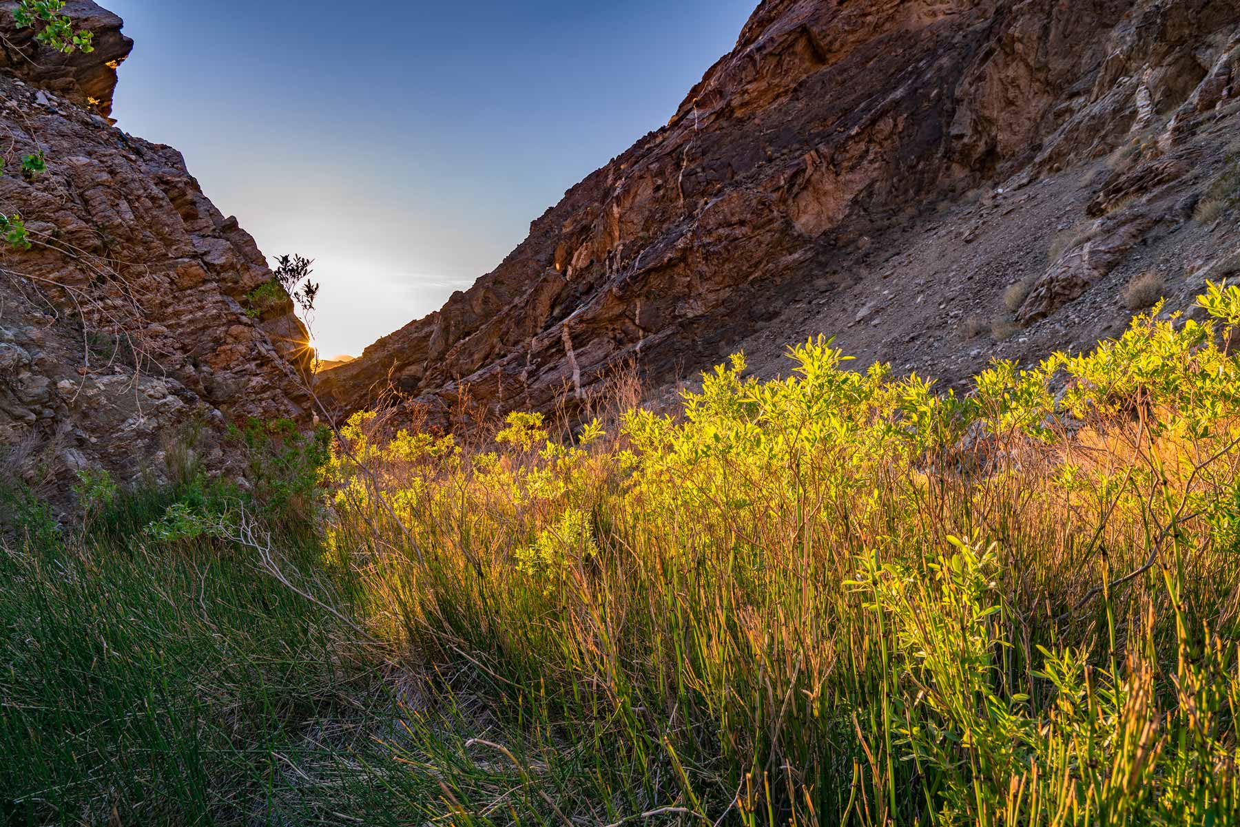
Mesquite Flat Sand Dunes are best at sunrise or sunset, but skip the marked trail and just walk into the dunes. There is no set path, and you will find solitude 10 minutes from the parking lot. Full moon nights here are surreal.
Western Park
The western side of Death Valley is where it starts to feel genuinely wild. Fewer people, rougher roads, bigger rewards. Darwin Falls, the charcoal kilns, and Telescope Peak all live out here.
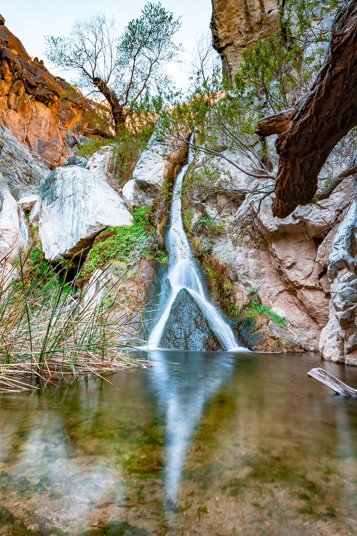
14. See Darwin Falls
Distance 1.9 mi RT Time 1-2 hrs Difficulty Easy-Moderate Vehicle Any car Drive from Furnace Creek 1 hr
Darwin Falls is a great addition to your list just for the sheer improbability of a waterfall existing here. When we first heard there was a year-round waterfall in Death Valley we thought it was too good to be true.
The main attraction is a series of cascading waterfalls, with the upper falls reaching about 75 feet and the lower falls around 20 feet. These falls plunge into a crystal-clear pool. The spring-fed water nourishes a vibrant landscape of trees, ferns, cattails, and other greenery, contrasting starkly with the surrounding desert terrain.
The trailhead starts just down the road from the Panamint Springs area. Shortly down the trail, a creek appears and the suspense builds. Seemingly out of nowhere, songbirds start singing, crickets start chirping, dragonflies begin buzzing, and even frogs start to croak. A year-round waterfall in the hottest place on earth. Death Valley never stops surprising-national-parks-near-detroit-youll-love-photos-guide/”>surprising us.
Trailhead: Off Highway 190 near Panamint Springs
Parking: Small dirt lot at the trailhead
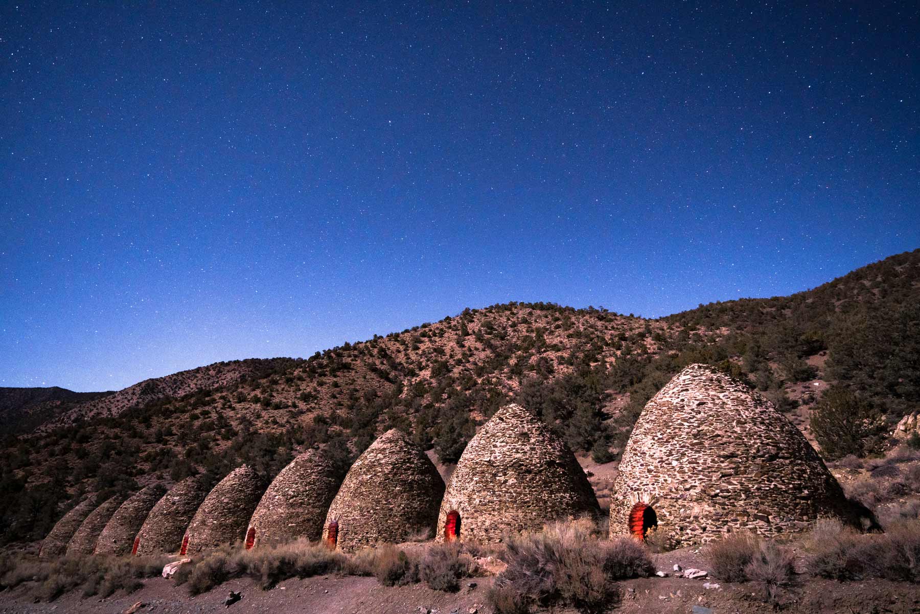
15. See the Wildrose Charcoal Kilns (by Night)
Distance Short walk from parking Time 1-2 hrs Difficulty Easy Vehicle High-clearance required, 4WD recommended Drive from Furnace Creek 1.5 hrs
If you’re looking for interesting historic things to do at Death Valley at night then add this one to your list. The Wildrose Charcoal Kilns are a cool spot to visit, easily mistaken for an abandoned village of windowless conical, beehive-shaped homes.
Built in 1877, the kilns were constructed by the Modock Consolidated Mining Company to provide fuel for their silver and lead mines located about 25 miles west in the Argus Range. These kilns were meticulously crafted from local stone and mortar, designed to efficiently convert wood into charcoal.
We decided to visit the kilns at night under a waxing moon to try and grab a cool photo and were glad we did. The combination of the beehive structures under a sky full of stars is truly unique to Death Valley.

16. Ascend Telescope Peak
Distance 14 mi RT Time 5-7 hrs Difficulty Strenuous Vehicle High-clearance required to trailhead Drive from Furnace Creek 1.5 hrs
Telescope Peak is the highest point in Death Valley National Park at 11,049 feet and is regularly snow-capped. We never thought we would see snow in Death Valley so this was a real shocker. Beyond the snow, there’s much that’s different about this area. As you ascend Charcoal Kiln Road to the trailhead, you’ll notice pinyon pines and junipers. Keep an eye out for the ancient bristlecone pines, some of the oldest living organisms on Earth.
Elevation gain: 3,200 feet
Best time to hike: Late spring through early fall (snow covers the trail in winter)
Trailhead elevation: 8,150 feet

17. See Panamint Dunes
Distance 7 mi RT Time 3-5 hrs Difficulty Strenuous Vehicle High-clearance recommended Drive from Furnace Creek 1 hr to trailhead
Panamint Dunes are a lesser-traveled dune field that most folks see from afar rather than actually visit themselves. The tallest dunes reach around 200 feet high and feature unusual star-shaped formations, unlike the linear ridges found in other Death Valley dunes.
Warning: Only attempt during cooler months. The heat can turn life-threatening in a hurry especially since these dunes are so remote.
Remote / Backcountry
This is where Death Valley really separates itself from every other park. These spots require time, planning, and usually a 4WD vehicle. They also reward you with the kind of solitude and scale that most folks will never experience. If you have three or more days, this is where you should spend them.

18. Explore Eureka Dunes
Distance Varies (open sand) Time 2-4 hrs Difficulty Moderate Vehicle High-clearance 4WD required Drive from Furnace Creek 3 hrs
Located in the remote Eureka Valley and situated at 3,000 feet elevation, Eureka Dunes is the most stunning dune field (of the five major dune fields) in the park. Eureka Dunes are the tallest dunes in California and perhaps the tallest in North America. The tallest peaks reach a staggering 680 feet (207 meters). But what makes this dune field even more impressive is the jaw-dropping backdrop of the colossal Last Chance Mountains.

And if that wasn’t enough to entice you to visit, did we mention they sing? No, really. Eureka Dunes sing underneath your feet. The phenomenon has puzzled scientists for years but under the right conditions you’ll hear a bassy resonance resembling that of a pipe organ.
Take warning, these dunes are deceptively tall, and climbing them requires quite an effort. It’s a difficult challenge and can be downright dangerous during the summer months when temperatures are blazing.

Of all the best things to do in Death Valley National Park, hiking Eureka Dunes is our personal favorite. The view from atop the dunes is incredible and since they’re fairly remote, there’s rarely a crowd here.
Camping: Eureka Dunes Campground has 7 primitive sites (no water, no fee). First come, first served.
Time needed: Half day minimum including the drive
Best time: Sunrise or sunset for photography. Avoid midday heat.
If you fall in love with dunes as we did, put Great Sand Dunes National Park on your list.

19. Venture Out to Saline Valley Dunes
Distance Varies Time 2-3 hrs at dunes Difficulty Easy-Moderate Vehicle High-clearance 4WD required Drive from Furnace Creek 3+ hrs
If you’re looking for some of the more isolated things to do at Death Valley, Saline Valley Dunes are perhaps the most remote in the park. Reaching a maximum height of around 100 feet, the Saline Valley Dunes offer a more approachable and less physically demanding exploration. Death Valley has 5 separate dune fields to choose from and these are probably at the bottom of that list for us. Our favorite are the Eureka Dunes. But if you’re out this way and want pure solitude, Saline Valley delivers.
Best for: Experienced desert explorers only. No services, no cell signal, nobody around.
20. Hike Through Surprise Canyon
Distance 6.3 mi RT Time 3-4 hrs Difficulty Moderate Vehicle High-clearance required Drive from Furnace Creek 2+ hrs (via roads outside the park)
If you’re looking for another unexpected activity then add Surprise Canyon to your list. The aptly named Surprise Canyon is a real treat featuring a lovely creek, some small waterfalls, and even burros! To get to the trailhead you must drive outside the park and then back up the canyon, so this is an activity for a longer stay or a repeat visit.
Note: Full disclosure, we witnessed a dead burro on this hike which is not uncommon so it might not be one of the best things to do in Death Valley with kids.

21. Discover the Lee Flat Joshua Tree Forest
Distance Varies Time 1-2 hrs Difficulty Easy Vehicle High-clearance recommended Drive from Furnace Creek 2.5 hrs
If you’re like us and figured you had to go to Joshua Tree National Park to see Joshua Trees, well, you don’t. It turns out Death Valley has massive Joshua Tree forests and perhaps none as large as the Lee Flat Joshua Tree Forest located near the west entrance to the park. We’ve visited numerous times and typically have the entire place to ourselves.
Lee Flat is situated at a much higher elevation than the valley floor and as such has a very different feel. Temperatures can be 20 or more degrees cooler here than what folks find at Badwater Basin. Sunset is an especially beautiful time to visit.
22. Venture Across Ibex Dunes
Distance Varies (1-3 mi) Time 2-3 hrs Difficulty Moderate Vehicle High-clearance required Drive from Furnace Creek 1.5 hrs

If you’ve got a few days to explore then we highly recommend adding Ibex Dunes to your list. Ibex Dunes are perhaps the most photogenic dunes in the park (right up there with Eureka Dunes) and almost as remote. These dunes are located on the southern end of the park off of a rough, high-clearance road.
Ibex Dunes are a blast to explore but make sure to do so early as they heat up fast, even in winter. One of the coolest parts of exploring Ibex Dunes is finding the abandoned mine on the far side set against the mountains. As you explore, keep an eye out for Ibex Spring, a small oasis sitting on the eastern slope complete with palm trees and a small pool of water.
Pack: Way more water than you think you’ll need along with a sun hat and snacks.
Best Scenic Drives in Death Valley
A lot of folks don’t realize that Death Valley is the largest national park in the United States outside of Alaska. There are over 1,000 miles of roads within Death Valley National Park. Three hundred miles are paved, three hundred are improved, and the other six hundred are pretty much 4WD roads.

Titus Canyon Road is the best drive in the park, period. It’s a 27-mile one-way road that drops you through a narrow canyon with 500-foot walls on either side. Requires 4WD and takes about 3 hours. Enter from the east (Nevada side) off Highway 374. Not to be missed if you have the vehicle for it.
Badwater Road connects to Badwater Basin, Artists Palette, and Devils Golf Course. This is the drive most folks do on day one and any car can handle it. About 30 miles of paved road through the heart of the valley.
Emigrant Canyon Road takes you up into the western mountains toward the charcoal kilns and Telescope Peak trailhead. The views get better the higher you climb. Paved at the start, turns to gravel as you gain elevation.
Important: Make sure you have a good spare tire if you’re heading off-road. Service is spotty at best. If you break down on a dirt road it could be hours or days before someone finds you. Pack way more food and water than you think you’ll need. This is not an exaggeration.
If you have a high-clearance 4WD vehicle, the 27-mile dirt road to the Racetrack Playa (the famous sailing stones) is worth the effort. But check with the visitor center about road conditions first. A flat tire out there means a long, expensive day.
Things You’ll See Along the Way
These aren’t activities you plan for. They’re things that happen to you while you’re out doing everything else. Keep your eyes open.

Mud Cracks. Death Valley is famous for the geometric patterns that form when the valley floor dries and cracks. We won’t say exactly where we found our favorites (people are protective of these spots for good reason) but driving down Badwater Road south of Furnace Creek there are plenty of great examples. Look at the photos you see and try to match them with the mountains and topography.

Feral Burros. Imported by miners during the 19th century, burros are actually an invasive species and the park service is actively working to reduce the current population. Eventually these feral donkeys will be completely removed. Until then, they’re pretty cool to spot. We saw several in Surprise Canyon and near the Wildrose area.
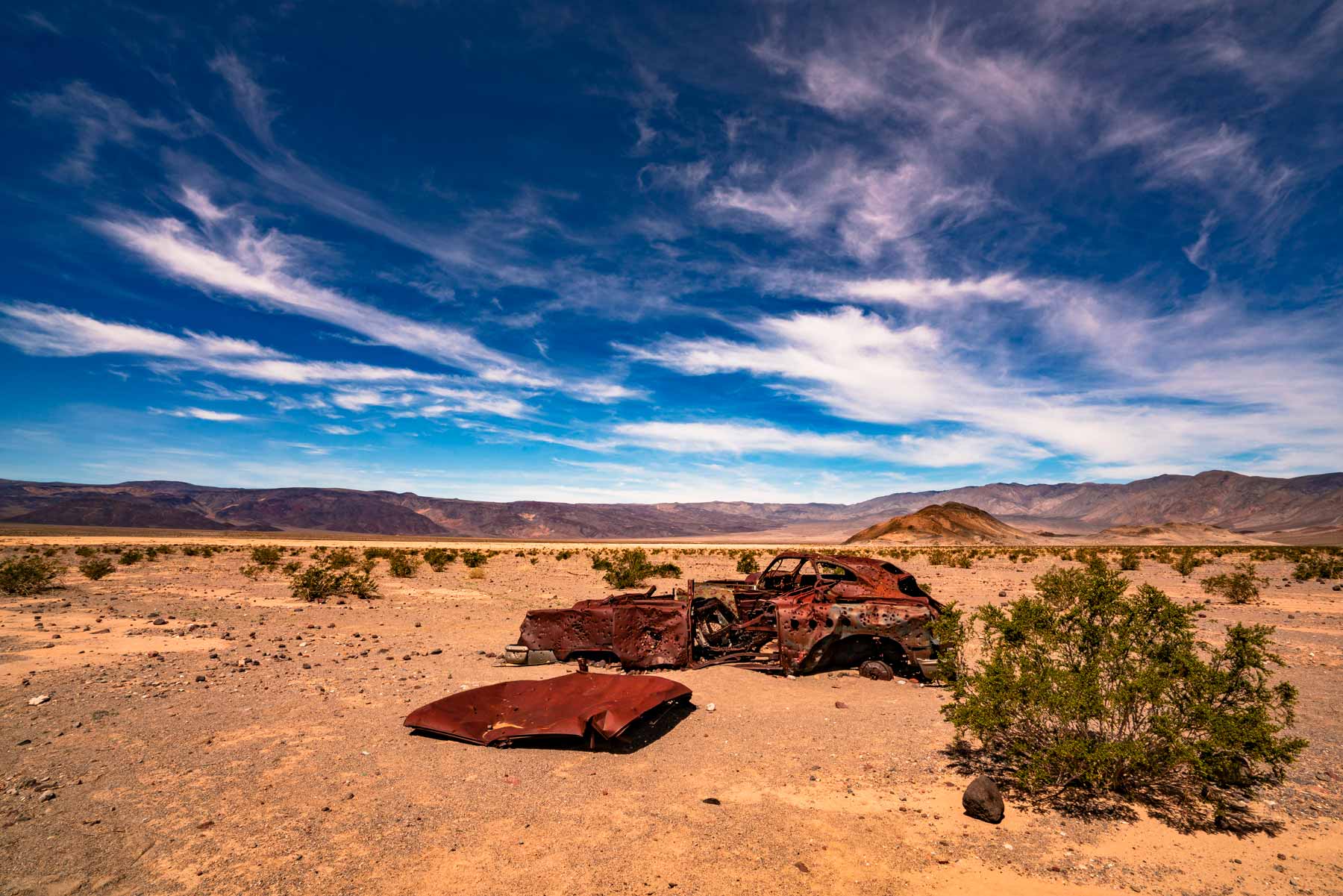
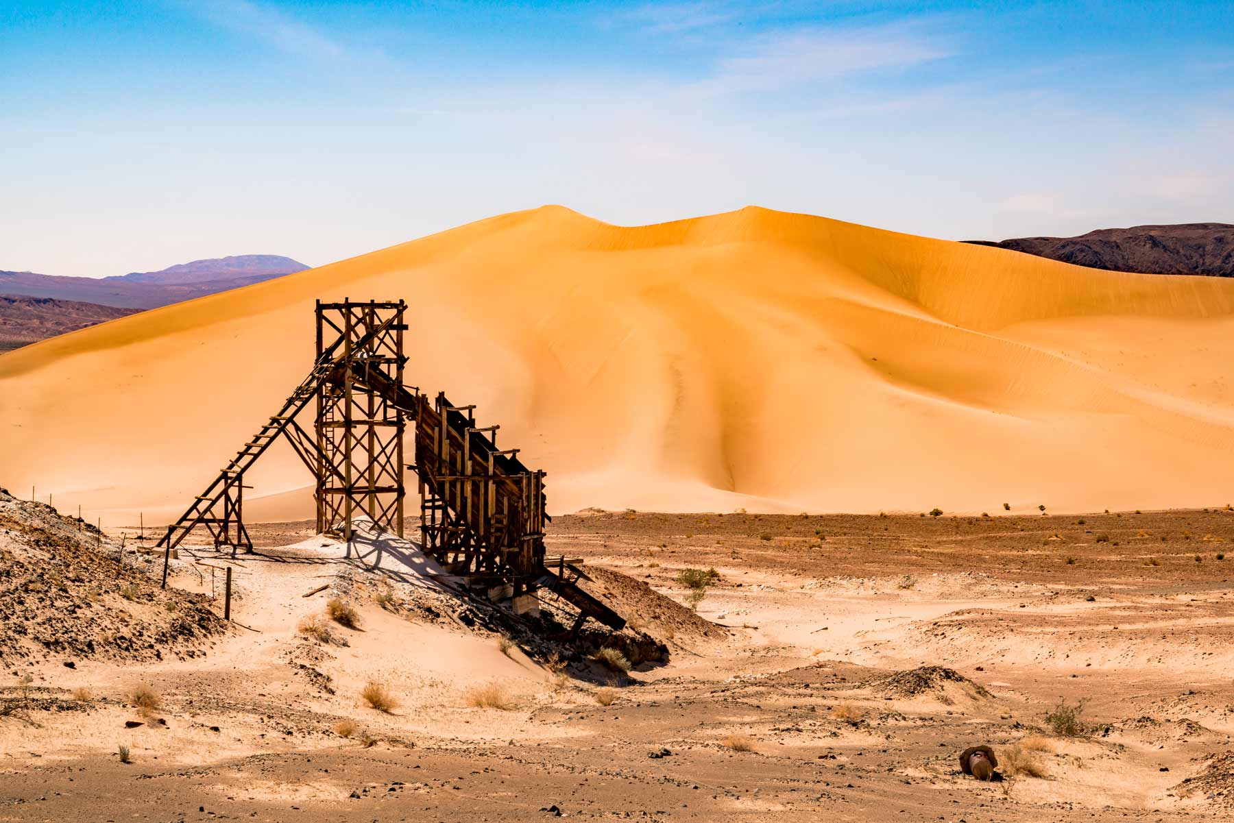
Abandoned Historical Remnants. Death Valley is full of artifacts from bygone eras: abandoned cars, mining equipment, tunnels (do not enter these). You are legally required to leave these objects just as you found them. Good spots include Ibex Dunes (old mining tower), Panamint Dunes Road (rusty cars), Aguereberry Point Road (Eureka Mine), and Harmony Borax Works.
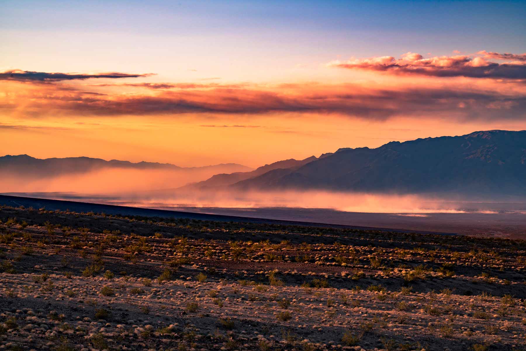
Sandstorms. One of the coolest things we’ve witnessed in Death Valley was a sandstorm moving across the desert during magic hour. The way the light illuminated the sand as it hurtled across the valley floor was spectacular. We waited too long to get into the car and boy did it sting. If you see one approaching, take cover. If you’re on higher ground, you just might get to spectate from above.
FAQ
Yes but it’s dangerous. Stick to early morning and evening. Carry 2 gallons of water per person per day. Don’t hike after 10am. Temperatures regularly exceed 120 degrees F and the ground surface can reach 200 degrees. We’ve done it and don’t recommend it for most folks.
For the main sights (Badwater, Zabriskie, Artists Palette, Mesquite Flat), no. Any car is fine. For the best stuff (Eureka Dunes, Racetrack Playa, Titus Canyon), yes. A high-clearance 4WD opens up about 600 additional miles of road in the park.
One day covers the highlights. Two days is comfortable. Three or more if you want the backcountry. We’ve spent weeks here total and still haven’t seen everything.
Dogs are allowed on paved roads and in developed areas only. Not on trails or backcountry roads. The heat can kill a dog in minutes. We are not exaggerating. Leave them at home or board them in Las Vegas.
Essentially no. Brief spots near Furnace Creek and Stovepipe Wells. Download everything offline before you arrive. Google Maps, AllTrails, whatever you need. Do it before you lose signal. We mean it.
$30 per vehicle, valid for 7 days. Or $80 for the America the Beautiful annual pass, which gets you into every national park in the country. If you’re visiting more than two parks this year, the annual pass pays for itself.
Map of Things to Do in Death Valley
There are many ways to get to Death Valley National Park. One of the most popular is flying into Las Vegas and making the 2-hour drive to the park. The second closest major city is Los Angeles at about 4 hours away.
Four-Wheel Drive isn’t an absolute must but it sure opens up your options. We’d recommend renting a 4WD vehicle but you’ll be able to see plenty of amazing things without one. Check out this helpful article for the best places to see in Death Valley with 4WD.
The Award-Winning Death Valley Video
We created this 3-minute video based on our travels to Death Valley. It won some awards and was even featured by National Geographic. If you’re planning a trip to the park we encourage you to take a few minutes and watch our film.

We visited Death Valley National Park for the first time on a whim in 2008 while on a road trip with friends. It was during the winter months and we found ourselves amazed by the heat (the park averages 80 degrees in the dead of winter). Since then we’ve returned scores of times because we simply can’t get enough. There is something seriously magical about this desert wonderland.

More From Death Valley
- Death Valley National Park Guide: Death Valley National Park Ultimate Guide
- Facts About Death Valley: 15 Fascinating Facts About Death Valley National Park
- Death Valley by Season: Spring | Summer | Fall | Winter
- Death Valley Camping: 9 Best Campgrounds in Death Valley
- Eureka Dunes: Visiting Eureka Dunes in Death Valley
More From California
- Joshua Tree Guide: Joshua Tree National Park Ultimate Guide
- Things to Do Joshua Tree: 25 Epic Things to Do at Joshua Tree National Park
- Things to Do Sequoia: 15 Epic Things to Do at Sequoia National Park
- National Parks Near Las Vegas: 6 Best National Parks Near Las Vegas
- West Coast Parks: 20 BEST West Coast National Parks Ranked by Experts
What to Bring to Death Valley
Gear we recommend for Death Valley. Affiliate links support our work at no cost to you.
Affiliate disclosure: Some links on this page earn us a small commission at no extra cost to you. We only recommend gear we actually use.